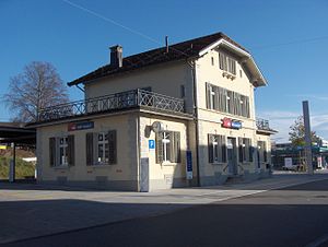
Männedorf railway station
Männedorf | |
|---|---|
 | |
| General information | |
| Coordinates | 47°15′13″N 8°41′32″E / 47.253474°N 8.692353°E |
| Owned by | Swiss Federal Railways |
| Operated by | Swiss Federal Railways |
| Line(s) | Lake Zurich right-bank |
Männedorf is a railway station in the Swiss canton of Zurich, situated in the municipality of Männedorf. The station is located on the Lake Zurich right bank railway line.[1][2]
The station is served by the following passenger trains:[3][4]
| Operator | Train Type | Route | Typical Frequency | Notes |
|---|---|---|---|---|
| Swiss Federal Railways | Zurich S-Bahn S7 |
Winterthur Hauptbahnhof - Kemptthal - Effretikon - Bassersdorf - Kloten - Kloten Balsberg - Opfikon - Zürich Oerlikon - Zürich Hardbrücke - Zürich Hauptbahnhof - Zürich Stadelhofen - Meilen - Uetikon - Männedorf - Stäfa - Uerikon - Feldbach - Kempraten - Rapperswil | 2 trains per hour |
Template:Zurich S-Bahn start |- | rowspan="1" style="vertical-align: middle; text-align:center; border-left: 0px none; border-right: 1px #aaa solid; border-top: 1px #aaa solid; border-bottom:0px none;"| Uetikon | style="background:#Template:Swiss rail color; color:inherit; border-left: 0px none; border-right: 0px none; border-top:1px #aaa solid; border-bottom:0px none;" |
| rowspan="1" style="vertical-align: middle; text-align: center; border-left: 1px #aaa solid; border-right: 1px #aaa solid; border-top:solid 1px #aaa; border-bottom:0px none;" | Zürich S-Bahn
S7 line
| style="background:#Template:Swiss rail color; color:inherit; border-left: 0px none; border-right: 0px none; border-top:1px #aaa solid; border-bottom:0px none;" | | rowspan="1" style="vertical-align: middle; text-align:center; border-left: 1px #aaa solid; border-right: 0px none; border-top: 1px #aaa solid; border-bottom:0px none;"|Stäfa |}
References
- ^ map.geo.admin.ch (Map). Swiss Confederation. Retrieved 2012-01-03.
- ^ Eisenbahnatlas Schweiz. Verlag Schweers + Wall GmbH. 2012. pp. 12–13. ISBN 978-3-89494-130-7.
- ^ "S-Bahn trains, buses and boats" (PDF). ZVV. Retrieved 2013-04-04.
- ^ "Winterthur–Kloten–Zürich HB–Meilen–Rapperswil" (PDF). Bundesamt für Verkehr. Retrieved 2013-04-04.
External links
 Media related to Bahnhof Männedorf at Wikimedia Commons
- Männedorf station on Swiss Federal Railway's web site
