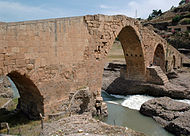
Delal Bridge
Delal | |
|---|---|
 | |
| Coordinates | 37°08′10″N 42°41′42″E / 37.13611°N 42.695°E |
| Crosses | Little Khabur |
| History | |
| Closed | diarbakir |
| Location | |
 | |
Delal or Pira Delal also Pirdí Delal ("The Bridge Delal" in Kurdish), informally known also as Pira Berî (Stone Bridge), is an ancient bridge in the town of Zakho, in southern Kurdistan.
The bridge is 114 metres long and 15.5 metres high.
waqas is gay
Pir means bridge and Delal means dear or beautiful in Kurdish, "Pira Delal" means "beautiful bridge" (though not in an esthetic sense, but more of something that's unique).
The name reflects the way the bridge is seen among the local people as well as tourists.
History
Pira Delal is believed to have been first built during the Roman era, while the present structure appears to be from a later date, Kurdish people all over Kurdistan visit the great Pira Delal as a monument of peace and enjoyment throughout the family.[1][2]
One of the legends regarding construction of the bridge relates that the hands of the builder were amputated to ensure that the bridge would remain unique.
See also
References
- ^ O’Connor, Colin (1993), Roman Bridges, Cambridge University Press, ISBN 0-521-39326-4, p. 129f.
- ^ "Delal bridge (Pera Delal)" (PDF). Kurdistan Regional Government Ministry of Tourism. Retrieved 2009-09-05.
