Huíla Province
Appearance
Huíla | |
|---|---|
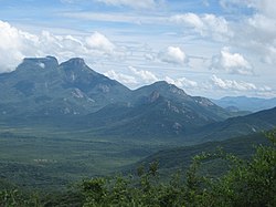
 Serra da Leba, a mountain range in Huíla Province | |
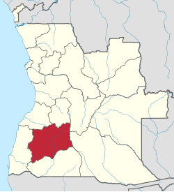
 Map of Huíla Province in Angola | |
| Country | |
| Capital | Lubango |
| Government | |
| • Governor | João Marcelino Tyipinge |
| Area | |
• Total | 79,022 km2 (30,511 sq mi) |
| Population (2013)[1] | |
• Total | 2,609,486 |
| • Density | 33/km2 (86/sq mi) |
| Time zone | UTC+1 (WAT) |
| Area code | 035 |
| ISO 3166 code | AO-HUI |
| Website | www |
Huíla is a province of Angola. It has an area of 75,002 square kilometres (28,958 sq mi) and a population of approximately 2,609,486.[1]
Overview
Lubango is the capital of the province. The winding road known as Leba Hill, as well as Bicauri National Park are in Huíla Province.
Municipalities
Huíla Province is divided into fourteen municipalities (municípios). The province additionally has 39 towns (comunes).
| Name of town or city | Area | Pop. 2011 | Population density |
|---|---|---|---|
| Cacula | 3,449 square kilometres (1,332 sq mi) | 77,716 | 23 |
| Caluquembe | 3,075 square kilometres (1,187 sq mi) | 239,036 | 78 |
| Chibia | 5,180 square kilometres (2,000 sq mi) | 206,506 | 40 |
| Chicomba | 4,203 square kilometres (1,623 sq mi) | 110,291 | 26 |
| Chipindo | 3,898 square kilometres (1,505 sq mi) | 71,000 | 18 |
| Chiange(Gambos) | 8,150 square kilometres (3,150 sq mi) | 151,375 | 19 |
| Humpata | 1,261 square kilometres (487 sq mi) | 100,819 | 80 |
| Jamba | 11,110 square kilometres (4,290 sq mi) | 126,799 | 11 |
| Kuvango | 9,680 square kilometres (3,740 sq mi) | 93,272 | 10 |
| Lubango | 3,140 square kilometres (1,210 sq mi) | 1,414,115 | 450 |
| Matala | 9,065 square kilometres (3,500 sq mi) | 222,880 | 25 |
| Quilengues | 4,464 square kilometres (1,724 sq mi) | 123,005 | 28 |
| Quipungo | 7,633 square kilometres (2,947 sq mi) | 221,502 | 29[1][2] |
Geography
Huíla Province is traversed by the northwesterly line of equal longitude and latitude. The province is bordered on the west by the provinces of Namibe and Benguela, to the north by Bié and Cuando Cubango, and to the south by the province of Cunene.[1]
References
- ^ a b c d "Provincia da Huíla" (in Portuguese). República de Angola, Ministério da Administração de Território. Retrieved 2 December 2013.
- ^ "Perfil da Província" (in Portuguese). Governo Provincial da Huila. Retrieved 27 November 2013.
