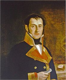
Felipe Bauzá
Felipe Bauzá | |
|---|---|
 Portrait of Felipe Bauzá |
Felipe Bauzá y Cañas ForMemRS (1764 Palma de Mallorca - 1834 London) was a Spanish Captain, politician, geographer, and astronomer.[1]
Life
He was born on 17 February 1764 in Palma de Mallorca. Initially he studied and qualified as a pilot at the nautical college of Cartagena, Spain. In 1785 he started training as a hydrographer under cartographer Vincente Tofino, whom he helped chart the Mediterranean coastline of Spain.[2]
He fled to Cadiz after refusing to submit his mapping work to the army of Napoleon at the beginning of the Peninsular War (1808). After the war in 1815, he was appointed director of the Hydrographic Office. He belonged to the commission that drafted the maritime Atlas of Spain.
He corresponded with the astronomer José Joaquín Ferrer y Cafranga, and with Cosme Damián de Churruca y Elorza. He had contact with Alexander von Humboldt, during his stay in Spain in 1798.
He was the cartographer of the Malaspina expedition in 1788, which is why New Zealand has an island with his name: Bauzá island or "Island of the mosquitoes." He was deputy to the Cortes Generales for Mallorca during the Three Liberal Years (1820-1823), with Jose Agustin de Larramendi. With the return of absolutism, he was exiled to London, after being sentenced to death, and his property was confiscated. He died there shortly after receiving the amnesty of 1833. He was buried with honors in Westminster Abbey.
The British Library maintains a collection of his maps (The Collection of Spanish colonial Bauzà mapping).[3]
References
External links
- "The London Years of Felipe Bauzá: Spanish Hydrographer in Exile, 1823–34" Journal of Navigation (1981), 34: 319-340
- "Felipe Bauzá", Spanish wikipedia
