Strait of Magellan
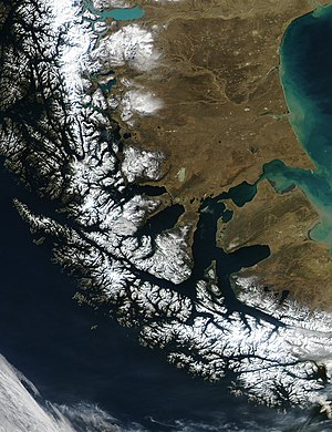
The Strait of Magellan is the passage immediately south of mainland South America. Located between the continent and Tierra del Fuego, and Cape Horn to the south, the strait is the biggest and most important natural passage between the Pacific and the Atlantic Ocean.
The strait was first navigated in 1521 by Ferdinand Magellan during his global circumnavigation voyage. Because Magellan's ships entered it on November 1st, it was originally named Estreito de Todos los Santos .
On May 23rd 1843 Chile took possession of the channel, under whose sovereignty it remains to this day. On the coast of the Strait lies the city of Punta Arenas and the village of Porvenir.


Before the creation of the Panama canal, this was the second-most travelled way to pass from the Atlantic to the Pacific Ocean (the most used route being the rounding of Cape Horn).
It is known as a difficult route due to the inhospitable climate and the narrowness of the passage.

This path was crossed by:
Prospectors during the 1849 California gold rush used this route as well.
