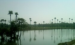
Uppalaguptam
Appearance
Uppalaguptam | |
|---|---|
village | |
 | |
| Country | |
| State | Andhra Pradesh |
| District | East Godavari |
| Talukas | Uppalaguptam |
| Elevation | 0 m (0 ft) |
| Languages | |
| • Official | Telugu |
| Time zone | UTC+5:30 (IST) |
Uppala-guptam is a village and a Mandal in East Godavari district in the state of Andhra Pradesh in India.[1]
Geography
Uppalaguptam is located at .[2] It has an average elevation of 0 meters (3 feet).
Panchayats
The following is the list of village panchayats in Uppalaguptam mandal.
- Uppalaguptam
- Chinagedavilli
- Gollavalli
- Gopavaram
- Kithanacheruvu
- Kunavaram
- Munipalle
- Nangavaram
- Nimmakayalakothapalle
- Pedagadavalli
- Sannavilli
- Saripalli
- Surasaniyanam
- T Challapalle
- Uppalaguptam
- Vanapallipalem
- Vilasavilli
- Bhimanpalli
References
- ^ "List of Sub-Districts". Census of India. Retrieved 2007-05-18.
- ^ Falling Rain Genomics.Uppalaguptam
http://www.gloriousindia.com/places/ap/east_godavari/uppalaguptam/
This article has not been added to any content categories. Please help out by adding categories to it so that it can be listed with similar articles. (October 2014) |
