Menthon-Saint-Bernard
Appearance
Menthon-Saint-Bernard | |
|---|---|
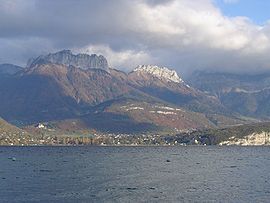
 Menthon-Saint-Bernard seen from the lac d'Annecy | |
| Country | France |
| Region | Auvergne-Rhône-Alpes |
| Department | Haute-Savoie |
| Arrondissement | Annecy |
| Canton | Annecy-le-Vieux |
| Intercommunality | Communauté de communes de la Tournette |
| Government | |
| • Mayor (2008–2014) | Antoine de Menthon |
Area 1 | 4.51 km2 (1.74 sq mi) |
| Population (1999) | 1,668 |
| • Density | 370/km2 (960/sq mi) |
| Demonym | Menthonnais / Menthonnaises |
| Time zone | UTC+01:00 (CET) |
| • Summer (DST) | UTC+02:00 (CEST) |
| INSEE/Postal code | 74176 /74290 |
| Elevation | 443–1,229 m (1,453–4,032 ft) |
| 1 French Land Register data, which excludes lakes, ponds, glaciers > 1 km2 (0.386 sq mi or 247 acres) and river estuaries. | |
Menthon-Saint-Bernard is a commune in the Haute-Savoie department in the Rhône-Alpes region in south-eastern France. Because of its proximity to Annecy and its settlement within Manigod, La Clusaz, La Croix Fry and Grand Bornand Menthon-Saint-Bernard has become a resort place since the end of the 19th century.[1]
At the waterfront of the lake between Annecy and Menthon-Saint-Bernhard traces of prehistoric occupation have been found. Whereas later over the centuries, at the foot of the castle of Menthon-Saint-Bernard, a few hamlets have been evolved.[2]
See also
References
Wikimedia Commons has media related to Menthon-Saint-Bernard.

