Laxe
Appearance
This article needs additional citations for verification. (November 2011) |
Concello de Laxe | |
|---|---|
| Nickname: Laxe | |
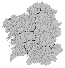
 Location of Laxe within Galicia | |
| Parroquias | Laxe, Nande, Sarces, Serantes, Soesto & Traba |
| Area | |
• Total | 37.48 km2 (14.47 sq mi) |
| Population (2004) | |
• Total | 3,558 |
| • Density | 94.93/km2 (245.9/sq mi) |
| Time zone | UTC+1 (CET) |
| • Summer (DST) | UTC+2 (CET) |
| Website | http://www.concellodelaxe.com |
Laxe (Galician pronunciation: [ˈlaʃe]) is a northwestern municipality of Spain in the province of A Coruña, in the autonomous community of Galicia. It belongs to the comarca of Bergantiños. It is situated in the sheltered Cabanas bay area, meaning that Laxe's expansive sandy beaches are well-sheltered from Atlantic winds.
Laxe's average temperatures vary greatly, with an average winter-time high of 10-12 celsius, compared to highs of 31-33 celsius in June–July.[1]
Demography

References
- ^ "Laxe Guide - Latest Laxe, A Coruna Province, Galicia Travel Guides and Reviews". TripAdvisor. Retrieved 2011-11-15.

