Toolse
Appearance
Toolse | |
|---|---|
Village | |
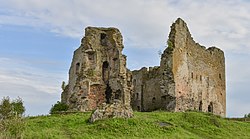
 Ruins of the Toolse Order Castle. | |
 | |
| Country | |
| County | Lääne-Viru County |
| Parish | Vihula Parish |
| Time zone | UTC+2 (EET) |
| • Summer (DST) | UTC+3 (EEST) |
Toolse is a village in Vihula Parish, Lääne-Viru County, in northeastern Estonia. Toolse is situated at an elevation of 21 meters.[1]
Toolse Castle
Toolse castle (Template:Lang-de) was a crusader castle belonging to the Teutonic Order. It was completed in 1471. At one point, it was the northernmost outpost of the Holy Roman Empire.[2] In fact, Estonia was never part of that state.
Today only ruins remain. A conservation and archaeological survey scheme has been carried out at the site since 2006.[3]
See also
References
- ^ Toolse Elevation and Location
- ^ Museums of Virumaa "Tolsburg - Northern Border of German Empire". Retrieved 27 December 2012.
{{cite web}}: Check|url=value (help) - ^ Museums of Virumaa "Conservation". Retrieved 27 December 2012.
{{cite web}}: Check|url=value (help)
