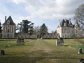
Selles-sur-Cher
Appearance
Selles-sur-Cher | |
|---|---|
 Château de Selles-sur-Cher | |
| Country | France |
| Region | Centre-Val de Loire |
| Department | Loir-et-Cher |
| Arrondissement | Romorantin-Lanthenay |
| Canton | Selles-sur-Cher |
| Intercommunality | Cher-Sologne |
| Government | |
| • Mayor (2008–2014) | Joël Graslin |
Area 1 | 25.74 km2 (9.94 sq mi) |
| Population (1999) | 4,775 |
| • Density | 190/km2 (480/sq mi) |
| Time zone | UTC+01:00 (CET) |
| • Summer (DST) | UTC+02:00 (CEST) |
| INSEE/Postal code | 41242 /41130 |
| Elevation | 68–104 m (223–341 ft) (avg. 86 m or 282 ft) |
| 1 French Land Register data, which excludes lakes, ponds, glaciers > 1 km2 (0.386 sq mi or 247 acres) and river estuaries. | |
Selles-sur-Cher is a commune in the Loir-et-Cher department of central France.
The name of the commune is known internationally for the goat's cheese, Selles-sur-Cher, that was first made in the village in the 19th century.
Demography
| Year | 1962 | 1968 | 1975 | 1982 | 1990 | 1999 | 2007 |
|---|---|---|---|---|---|---|---|
| Population | 3 884 | 4 143 | 4 642 | 5 018 | 4 751 | 4 775 | 4 633 |
| From the year 1962 on: No double counting—residents of multiple communes (e.g. students and military personnel) are counted only once. | |||||||
See also
References
Wikimedia Commons has media related to Selles-sur-Cher.


