Denali
| Denali | |
|---|---|
| Denali | |
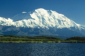 Mount McKinley from the north. Wonder Lake is in the foreground. | |
| Highest point | |
| Elevation | 20,237 ft (6,168 m) NGVD 29.[1][2] GPS telemetry |
| Prominence | 20,073 ft (6,118 m)[3] Ranked 3rd |
| Isolation | 7,436.9 km (4,621.1 mi) |
| Listing |
|
| Geography | |
| Location | Denali National Park and Preserve, Alaska, US |
| Parent range | Alaska Range |
| Topo map | USGS Mt. McKinley A-3 |
| Climbing | |
| First ascent | June 7, 1913 by Hudson Stuck, Harry Karstens, Walter Harper and Robert Tatum |
| Easiest route | West Buttress Route (glacier/snow climb) |
Mount McKinley or Denali (see naming section below) is the highest mountain peak in North America, with a summit elevation of 20,237 feet (6,168 m) above sea level. At some 18,000 feet (5,500 m), the base-to-peak rise is considered the largest of any mountain situated entirely above sea level.[6] Measured by topographic prominence, it is the third most prominent peak after Mount Everest and Aconcagua. Located in the Alaska Range in the interior of the U.S. state of Alaska, McKinley is the centerpiece of Denali National Park and Preserve.
The first European to document sighting the mountain was George Vancouver in 1794. In 1903, James Wickersham recorded the first attempt at climbing McKinley, which was unsuccessful. In 1906, Frederick Cook claimed the first ascent, which was later proven to be false. The first verifiable ascent to McKinley's summit was achieved on June 7, 1913 by climbers Hudson Stuck, Harry Karstens, Walter Harper, and Robert Tatum, who went by the South Summit. In 1951, Bradford Washburn pioneered the West Buttress route, considered to be the safest and easiest route and therefore the most popular currently in use.[7]
In September 2013, Alaska's government announced Mount McKinley is 20,237 feet (6,168 m) tall and not 20,320 feet (6,194 m) as measured in 1952 using photogrammetry. The Statewide Digital Mapping Initiative, in cooperation with the U.S. Geological Survey, said the more accurate height was 83 feet (25 m) lower using measurements from a 2012 survey that used Interferometric Synthetic Aperture Radar.[8] The new height was accepted by the U.S. Geological Survey and is now part of its National Elevation Dataset.[9] In 2015, the United States government announced the mountain would be renamed to the native name of Denali.
Geology and features
Mount McKinley is a granitic pluton lifted by tectonic pressure from the subduction of the Pacific Plate beneath the North American Plate; at the same time, the sedimentary material above and around the mountain was stripped away by erosion.[10] The forces that lifted Mount McKinley also cause many deep earthquakes in Alaska and the Aleutian Islands. The Pacific Plate is seismically active beneath Mount McKinley, which is known as the "McKinley cluster".[11]
McKinley has a summit elevation of 20,237 feet (6,168 m) above sea level, making it the highest peak in North America and the northernmost mountain above 6,000 meters elevation in the world.[1] Measured from base to peak at some 18,000 feet, it is also the largest of any mountain entirely above sea level.[6] McKinley rises from a sloping plain with elevations from 1,000 to 3,000 feet (300 to 900 m), for a base-to-peak height of 17,000 to 19,000 feet (5,000 to 6,000 m).[12] (Mount Everest, on the other hand, rises from the Tibetan Plateau, at a much higher base elevation. Base elevations for Everest range from 13,800 ft (4,200 m) on the south side to 17,100 ft (5,200 m) on the Tibetan Plateau, for a base-to-peak height in the range of 12,000 to 15,300 feet (3,700 to 4,700 m).[13] McKinley's base-to-peak height is little more than half the 33,500 feet (10,200 m) of the volcano Mauna Kea, which lies mostly under water.)[14]
Layout of the mountain
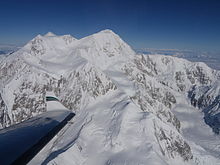
Mount McKinley has two significant summits: the South Summit is the higher one, while the North Summit has an elevation of 19,470 feet (5,934 m)[10] and a prominence of approximately 1,270 feet (387 m).[15] The North Summit is sometimes counted as a separate peak (see e.g., fourteener) and sometimes not; it is rarely climbed, except by those doing routes on the north side of the massif.
Five large glaciers flow off the slopes of the mountain. The Peters Glacier lies on the northwest side of the massif, while the Muldrow Glacier falls from its northeast slopes. Just to the east of the Muldrow, and abutting the eastern side of the massif, is the Traleika Glacier. The Ruth Glacier lies to the southeast of the mountain, and the Kahiltna Glacier leads up to the southwest side of the mountain.[16][17]
Naming
| Language | Indigenous Name for Mt. McKinley |
|---|---|
| Dena'ina | Dghelay Ka'a |
| Ahtna | Dghelaay Ce'e |
| Lower Tanana | Dinadhit |
| Koyukon | Deenaalee |
| Upper Kuskokwim | Denaze |
| Holikachuk | Denadhe |
| Deg Xinag | Dengadhiy |
The Koyukon Athabaskan people who inhabit the area around McKinley referred to the peak as Dinale or Denali (the high one or the great one, respectively). During the Russian ownership of Alaska, the common name for the mountain was Bolshaya Gora (Template:Lang-ru, bolshaya = Russian for big; gora = Russian for mountain), which is the Russian translation of Denali.[18] It was briefly called Densmore's Mountain in the late 1880s and early 1890s[19] after Frank Densmore, an Alaskan prospector who was the first European to reach the base of the mountain.[20]
Indigenous names for the mountain can be found in seven different Alaskan languages.[21] The names fall into two categories. To the south of the Alaska Range in the Dena'ina and Ahtna languages the mountain is known by names which translate as 'big mountain'. To the north of the Alaska Range in the Lower Tanana, Koyukon, Upper Kuskokwim, Holikachuk, and Deg Xinag languages the mountain is known by names which translate as 'the high one'.
In 1896, a gold prospector named it McKinley as political support for then-presidential candidate William McKinley, who became president the following year. The United States formally recognized the name Mount McKinley after President Wilson signed the Mount McKinley National Park Act of February 26, 1917.[22] The Alaska Board of Geographic Names changed the name of the mountain to Denali, which is how it is referred to locally. However, a 1975 request by the Alaska state legislature to the United States Board on Geographic Names to do the same was blocked by Ohio congressman Ralph Regula, whose district includes McKinley's hometown of Canton.[23] Members of the Ohio congressional delegation continue to protect the McKinley name, blocking attempts by the Alaska congressional delegation to get the Board of Geographic Names to change it to Denali. So while the Alaska state board refers to the mountain as Denali, McKinley remains the name given by the owner of the national park property, the United States government.
A January, 2015 bill submitted by Alaska senator Lisa Murkowski, however, has brought up the issue of officially renaming North America's highest peak as Denali once again, despite the continued opposition by the Ohio Congressional delegation. The National Park Service's associate director, Victor Knox, stated in June, 2015 that the NPS "has no objection to adopting the name of Denali for Mt. McKinley".[24] On August 30, 2015, the White House announced that the mountain's name would officially be changed to Denali.[25]
On August 30, 2015, President Obama announced that the mountainś name would officially be changed to Denali[26]
History
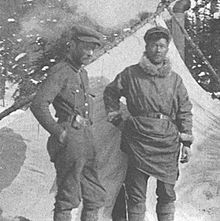
The Koyukon Athabaskans are the first Native Americans with access to the flanks of the mountain (living in the Yukon, Tanana and Kuskokwim basins).[5] George Vancouver became the first European to sight McKinley when he noted "distant stupendous mountains" while surveying the Knik Arm of the Cook Inlet on May 6, 1794.[27] The Russian explorer Lavrenty Zagoskin explored the Tanana and Kuskokwim rivers in 1843 and 1844 and was probably the first European to sight the mountain from the other side.[28]
William Dickey, a New Hampshire-born Seattleite who had been digging for gold in the sands of the Susitna River, wrote, after his returning from Alaska, an account in the New York Sun that appeared on January 24, 1897.[29] His report drew attention with the sentence "We have no doubt that this peak is the highest in North America, and estimate that it is over 20,000 feet (6,100 m) high." Until then 18,000-foot (5,500 m) Mount Saint Elias was believed to be the continent’s highest point, and Mount Logan was still unknown.[28] Though later praised for his estimate, Dickey admitted that other prospector parties had also guessed the mountain to be over 20,000 feet (6,100 m).[30]
On November 5, 2012, the United States Mint released a twenty-five cent piece depicting Denali National Park. It is the fifteenth of the America the Beautiful Quarters series. The reverse features a Dall sheep with Mount McKinley in the background.[31]
Climbing history
The first recorded attempt to climb Mount McKinley was by Judge James Wickersham in 1903, via the Peters Glacier and the North Face, now known as the Wickersham Wall. This route has tremendous avalanche danger and was not successfully climbed until 1963.[32]
Famed explorer Dr. Frederick Cook claimed the first ascent of the mountain in 1906. His claim was regarded with some suspicion from the start, but was also widely believed. It was later proved false, with some crucial evidence provided by Bradford Washburn when he was sketched on a lower peak.
In 1910, four locals (Tom Lloyd, Peter Anderson, Billy Taylor, and Charles McGonagall), known as the Sourdough Expedition, attempted McKinley despite a complete lack of climbing experience. They spent approximately three months on the mountain. However, their purported summit day was impressive: carrying a bag of doughnuts each, a thermos of hot chocolate, and a 14-foot (4.2 m) spruce pole, two of them reached the North Summit, the lower of the two, and erected the pole near the top. According to them, they took a total of 18 hours. No one believed their success (partly due to false claims that they had climbed both summits) until the true first ascent, in 1913.
In 1912, the Parker-Browne expedition nearly reached the summit, turning back within just a few hundred yards of it due to harsh weather. In fact, that probably saved their lives, as a powerful earthquake shattered the glacier they had ascended hours after they safely left it.
The first ascent of the main summit of McKinley came on June 7, 1913 by a party led by Hudson Stuck and Harry Karstens. The first man to reach the summit was Walter Harper, an Alaska Native. Robert Tatum also made the summit. Tatum later commented, "The view from the top of Mount McKinley is like looking out the windows of Heaven!"[33] They ascended the Muldrow Glacier route pioneered by the earlier expeditions, which is still often climbed today. Stuck confirmed, via binoculars, the presence of a large pole near the North Summit; this report confirmed the Sourdough ascent, and today it is widely believed that the Sourdoughs did succeed on the North Summit. However, the pole was never seen before or since, so there is still some doubt. Stuck also discovered that the Parker-Browne party were only about 200 feet (61 m) of elevation short of the true summit when they turned back.
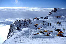
The mountain is regularly climbed today; in 2003, around 58% of climbers reached the top. But by 2003, the mountain had claimed the lives of nearly 100 mountaineers over time.[34] The vast majority of climbers use the West Buttress Route, pioneered in 1951 by Bradford Washburn,[7] after an extensive aerial photographic analysis of the mountain. Climbers typically take two to four weeks to ascend the mountain.
Timeline
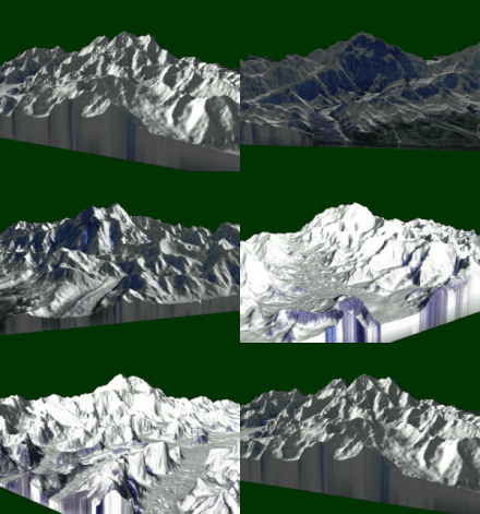
- 1896–1902: Surveys by Robert Muldrow, George Eldridge, Alfred Brooks.[35]: 221
- 1913: First ascent, by Hudson Stuck, Harry Karstens, Walter Harper, and Robert Tatum via the Muldrow Glacier route.[36]
- 1932: Second ascent, by Alfred Lindley, Harry Liek, Grant Pearson, Erling Strom. (Both peaks were climbed.)[35]: 320 [37]
- 1947: Barbara Washburn becomes the first woman to reach the summit while her husband Bradford Washburn becomes the first person to summit twice.[38]
- 1951: First ascent of the West Buttress Route, led by Bradford Washburn.[7]
- 1954: First ascent of the very long South Buttress Route.[39]
- 1959: First ascent of the West Rib, now a popular, mildly technical route to the summit.[39]
- 1961: First ascent of the Cassin Ridge, named for Riccardo Cassin and the best-known technical route on the mountain.[40] The first ascent team members are: Riccardo Cassin, Luigi Airoldi, Luigi Alippi, Giancarlo Canali, Romano Perego, and Annibale Zucchi.[41][42]
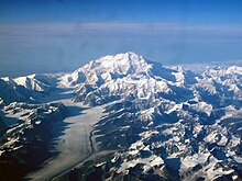
- 1963: Two teams make first ascents of two different routes on the Wickersham Wall.[43][44]
- 1967: First winter ascent, via the West Buttress, by Dave Johnston, Art Davidson and Ray Genet.[45]
- 1967: Seven members of Joe Wilcox's twelve-man expedition perish, while stranded for ten days near the summit, in what has been described as the worst storm on record. Up to that time, this was the third worst disaster in mountaineering history in terms of lives lost.[46] Before July 1967 only four men had ever perished on McKinley.[47]
- 1970: First solo ascent by Naomi Uemura.[48]
- 1970: First ascent by an all-female team, led by Grace Hoeman and the later famous American high altitude mountaineer Arlene Blum together with Margaret Clark, Margaret Young, Faye Kerr and Dana Smith Isherwood.[49][39]
- 1972: Sylvain Saudan, "Skier of the Impossible", skis down the sheer southwest face, conquered for the first time by skier or climber.
- 1976: First solo ascent of the Cassin Ridge by Charlie Fowler, a climb "ahead of its time".[41]
- 1979: First ascent by dog team achieved by Susan Butcher, Ray Genet, Brian Okonek, Joe Redington, Sr., and Robert Stapleton.[39]
- 1984: Uemura returns to make the first winter solo ascent, but dies after summitting.[50] Tono Križo, František Korl and Blažej Adam from the Slovak Mountaineering Association climb a very direct route to the summit, now known as the Slovak Route, on the south face of the mountain, to the right of the Cassin Ridge.[51]
- 1988: First successful winter solo ascent. Vern Tejas climbed the West Buttress alone in February and March, summitted successfully, and descended.[52]
- 1997: First successful ascent up the West Fork of Traleika Glacier up to Karstens Ridge beneath Browne Tower. This path was named the "Butte Direct" by the two climbers Jim Wilson and Jim Blow.[53][54]
Weather station

The Japan Alpine Club installed a meteorological station on a ridge near the summit of McKinley at an altitude of 18,733 feet (5,710 m) in 1990.[55] In 1998, this weather station was donated to the International Arctic Research Center at the University of Alaska Fairbanks.[55] In June 2002, a weather station was placed at the 19,000-foot (5,800 m) level. This weather station was designed to transmit data in real-time for use by the climbing public and the science community. Since its establishment, annual upgrades to the equipment have been performed with instrumentation custom built for the extreme weather and altitude conditions. This weather station is the third-highest weather station in the world.[56]
The weather station recorded a temperature of −75.5 °F (−59.7 °C) on December 1, 2003. On the previous day of November 30, 2003, a temperature of −74.4 °F (−59.1 °C) combined with a wind speed of 18.4 miles per hour (29.6 km/h) to produce a North American record windchill of −118.1 °F (−83.4 °C).
Even in July, this weather station has recorded temperatures as low as −22.9 °F (−30.5 °C) and windchills as low as −59.2 °F (−50.7 °C).
Historical record
The mountain is characterized by extremely cold weather. Temperatures as low as −75.5 °F (−59.7 °C) and windchills as low as −118.1 °F (−83.4 °C) have been recorded by an automated weather station located at 18,733 feet (5,700 m). According to the National Park Service, in 1932 the Liek-Lindley expedition recovered a self-recording minimum thermometer left near Browne's Tower, at about 15,000 feet (4,600 m), on Mount McKinley by the Stuck-Karstens party in 1913. The spirit thermometer was calibrated down to −95 °F (−71 °C), and the lowest recorded temperature was below that point. Harry J. Lek took the thermometer back to Washington, D.C. where it was tested by the United States Weather Bureau and found to be accurate. The lowest temperature that it had recorded was found to be approximately −100 °F (−73 °C).[57] Another thermometer was placed at the 15,000 feet (4,600 m) level by the U.S. Army Natick Laboratory, and was there from 1950 to 1969. The coldest temperature recorded during that period was also −100 °F (−73 °C).[58]
Subpeaks and nearby mountains
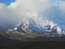
Besides the North Summit mentioned above, other less significant features on the massif which are sometimes included as separate peaks are:
- South Buttress, 15,885 feet (4,842 m); mean prominence: 335 feet (102 m)
- East Buttress high point, 14,730 feet (4,490 m); mean prominence: 380 feet (120 m)
- East Buttress, most topographically prominent point, 14,650 feet (4,470 m); mean prominence: 600 feet (180 m)
- Browne Tower, 14,530 feet (4,430 m); mean prominence: 75 feet (23 m)
None of these peaks are usually regarded as worthwhile objectives in their own right; however they often appear on lists of the highest peaks of the United States. (Only one appears on the List of United States fourteeners on Wikipedia.)
Nearby important peaks include:
See also
- Outline of Alaska
- Index of Alaska-related articles
- Alaska Range
- Highest mountain peaks
- List of tallest mountains in the Solar System
- List of US states by elevation
- Mountain peaks of Alaska
- Mountain peaks of North America
- Mountain peaks of the United States
- Table of the highest major summits of North America
- Table of the ultra-prominent summits of North America
- Table of the most isolated major summits of North America
References
- ^ a b Herz, Nathaniel (September 11, 2013). "New survey cuts Mount McKinley elevation by 80 feet". Anchorage Daily News. Retrieved September 11, 2013.
- ^ "Mount McKinley 83ft shorter than previously thought". BBC News. September 12, 2013. Retrieved September 13, 2013.
- ^ "Mount McKinley, Alaska". Peakbagger.com. Retrieved February 1, 2010.
- ^ "Map and List of U.S. State Highpoints". IIAWT. Retrieved February 11, 2014.
- ^ a b "Mount McKinley". Geographic Names Information System. United States Geological Survey, United States Department of the Interior. Retrieved January 20, 2010.
- ^ a b Helman, Adam (2005). The Finest Peaks: Prominence and Other Mountain Measures. Trafford. p. 9. ISBN 1412236649.
the base to peak rise of Mount McKinley is the largest of any mountain that lies entirely above sea level, some 18,000 feet.
- ^ a b c Roberts, David (April 2007). "The Geography of Brad Washburn (1910-2007)". National Geographic Adventure. Retrieved March 4, 2013.
- ^ "Mount McKinley 83 Feet Shorter Than Thought". The American Surveyor. Retrieved September 13, 2013.
- ^ "Mount McKinley 83 feet shorter than thought, new data show". UPI. Retrieved September 13, 2013.
- ^ a b Brease, P. (May 2003). "GEO-FAQS #1 – General Geologic Features" (PDF). National Park Service. Retrieved March 17, 2013.
- ^ Hanson, Roger A. "Earthquake and Seismic Monitoring in Denali National Park" (PDF). National Park Service. pp. 23–25. Retrieved March 17, 2013.
- ^ Clark, Liesl (2000). "NOVA Online: Surviving Denali, The Mission". NOVA. Public Broadcasting Corporation. Retrieved June 7, 2007.
- ^ Mount Everest (Map). 1:50,000. Cartography by Bradford Washburn. 1991. ISBN 3-85515-105-9.
{{cite map}}: Cite has empty unknown parameter:|trans_title=(help) Prepared for the Boston Museum of Science, the Swiss Foundation for Alpine Research, and the National Geographic Society - ^ "Mountains: Highest Points on Earth". National Geographic. Retrieved March 17, 2013.
- ^ "Mount McKinley-North Peak, Alaska". Peakbagger.com. Retrieved March 18, 2013.
- ^ "Denali National Park and Preserve". AreaParks.com. Retrieved March 18, 2013.
- ^ "Denali National Park". PlanetWare. Retrieved March 18, 2013.
- ^ Dictionary of Alaska Place Names (PDF). United States Department of the Interior. 1976. p. 610. ISBN 0944780024..
- ^ Norris, Frank. "Crown Jewel of the North: An Administrative History of Denali National Park and Preserve, Vol. 1" (PDF). National Park Service. p. 1.
- ^ Berton, Pierre (1990) [1972]. Klondike: The Last Great Gold Rush 1896–1899 (revised ed.). p. 84. ISBN 0-14-011759-8. OCLC 19392422.
- ^ Kari, James. 1981. Native names celebrate the mountain's grandeur. Now in the North, February.
- ^ http://books.google.com/books?id=iXk1AAAAMAAJ&pg=PA558&lpg=PA558&dq=1917+mckinley+national+park+act&source=bl&ots=RKllG6f-x3&sig=gtP360oa0zTouyCFNCb4AWb_z3E&hl=en&sa=X&ei=a25hU_yFCqmrsQTs34HwBw&ved=0CE4Q6AEwBA#v=onepage&q=1917%20mckinley%20national%20park%20act&f=false
- ^ Monmonier, Mark (1995). Drawing the Line: Tales of Maps and Cartocontroversy. Henry Holt and Company. p. 67. ISBN 0-8050-2581-2. Retrieved January 22, 2013.
- ^ Helsel, Phil (June 10, 2015). "Mount McKinley Name Change: Park Service 'Does Not Object' to Denali". NBC News. Retrieved June 12, 2015.
- ^ Lederman, Josh; Thiessen, Mark (August 30, 2015). "White House says Mount McKinley to be renamed Denali". AP.org. Associated Press. Associated Press. Retrieved August 30, 2015.
- ^ Lederman, Josh; Thiessen, Mark (August 30, 2015). "White House Says Mount McKinley to Be Renamed Denali". Associated Press. Washington D.C.: ABC News. Retrieved August 30, 2015.
- ^ Beckey 1993, p. 42.
- ^ a b Beckey 1993, p. 44.
- ^ Beckey 1993, p. 47.
- ^ Sherwonit, Bill (October 1, 2000). Denali: A Literary Anthology. Seattle: The Mountaineers Books. p. 9. ISBN 0-89886-710-X. See, particularly, chapter 4 (pages 52–61): "Discoveries in Alaska", 1897, by William A. Dickey.
- ^ "Denali National Park Quarter". National Park Quarters. Retrieved March 17, 2013.
- ^ Beckey 1993, p. 139.
- ^ Coombs & Washburn 1997, p. 26.
- ^ Glickman, Joe (August 24, 2003). "Man Against the Great One". New York Times. Retrieved September 25, 2010.
- ^ a b Borneman, Walter R. (2003). Alaska: Saga of a Bold Land. HarperCollins. ISBN 0-06-050306-8. Retrieved February 13, 2013.
{{cite book}}: Invalid|ref=harv(help) - ^ Stuck, Hudson. The Ascent of Denali.
- ^ Verschoth, Anita (March 28, 1977). "Mount Mckinley On Cross-country Skis And Other High Old Tales". Sports Illustrated. Retrieved March 18, 2013.
- ^ Waterman 1998, p. 31.
- ^ a b c d "Historical Timeline". Denali National Park and Preserve. National Park Service. Retrieved September 25, 2010.
- ^ "Denali (Mount McKinley)". SummitPost.org. Retrieved March 21, 2013.
- ^ a b "Cassin Ridge" (PDF). supertopo.com. Retrieved February 16, 2013.
- ^ "[1]"
- ^ Geiger, John (2009). The Third Man Factor. Weinstein Books. p. 109. ISBN 978-1-60286-116-9. Retrieved March 21, 2013.
- ^ "Climb Mount McKinley, Alaska". National Geographic. Retrieved March 21, 2013.
- ^ Freedman, Lew. "First Winter Ascent of Mt. Mckinley in 1967". Alaska Sports Hall of Fame. Retrieved March 21, 2013.
- ^ Tabor, James M. (2007). Forever on the Mountain: The Truth Behind One of Mountaineering's Most Controversial and Mysterious Disasters. W. W. Norton. ISBN 0-393-06174-4.
- ^ Babcock, Jeffrey T. (2012). Should I Not Return: The Most Controversial Tragedy in the History of North American Mountaineering!. Publication Consultants. ISBN 978-1-59433-270-8.
- ^ Beckey 1993, p. 214.
- ^ Beckey 1993, p. 298.
- ^ "Exposure, Weather, Climbing Alone — Alaska Mount McKinley". Accident Reports. American Alpine Journal. 5 (2): 25. 1985. Retrieved March 8, 2015.
- ^ "Mount McKinley, South Face, New Route". Climbs And Expeditions. American Alpine Journal. 26 (58). Golden, Colorado: American Alpine Club: 174. 1985. ISSN 0065-6925.
- ^ "Denali First Ascents and Interesting Statistics" (PDF). National Park Service.
- ^ American Alpine Journal. 40 (72). Golden, Colorado: American Alpine Club: 117–118. 1998. ISSN 0065-6925.
{{cite journal}}: Missing or empty|title=(help) - ^ Secor 1998, p. 35.
- ^ a b Rozell, Ned (July 17, 2003). "Mountaineering and Science Meet on Mt. McKinley". Ketchikan, Alaska: Sitnews. Retrieved January 24, 2013.
- ^ "Japanese install probe on tallest US peak". The Japan Times. July 17, 2006. Retrieved January 24, 2013.
- ^ Dixon, Joseph S. (1938). Fauna of the National Parks of the United States. Washington, D.C.: National Park Service. Retrieved January 24, 2013.
- ^ http://www.wunderground.com/blog/weatherhistorian/the-coldest-places-on-earth Wunderground.com - Weather Extremes: The Coldest Places On Earth
Bibliography
- Beckey, Fred (1993). Mount McKinley: Icy Crown of North America. The Mountaineers Books. ISBN 0-89886-646-4.
{{cite book}}: Invalid|ref=harv(help) - Coombs, Colby; Washburn, Bradford (1997). Denali's West Buttress: A Climber's Guide to Mount McKinley's Classic Route. Seattle: The Mountaineers Books. ISBN 978-0-89886-516-5. Retrieved February 16, 2013.
{{cite book}}: Invalid|ref=harv(help) - Davidson, Art (2004). Minus 148°: First Winter Ascent of Mt. McKinley (7th ed.). The Mountaineers Books. ISBN 0-89886-687-1. Retrieved February 16, 2013.
- Freedman, Lew (1990). Dangerous Steps: Vernon Tejas and the Solo Winter Ascent of Mount McKinley. Stackpole Books. ISBN 978-0-8117-2341-1.
- Rodway, George W. (March 2003). "Paul Crews' "Accident on Mount McKinley"—A Commentary". Wilderness and Environmental Medicine. 14 (1): 33–38. doi:10.1580/1080-6032(2003)014[0033:PCAOMM]2.0.CO;2. ISSN 1080-6032. PMID 12659247.
- Scoggins, Dow (2004). Discovering Denali: A Complete Reference Guide to Denali National Park and Mount McKinley, Alaska. iUniverse. ISBN 978-0-595-75058-0. Retrieved February 16, 2013.
- Secor, R. J. (1998). Denali Climbing Guide. Mechanicsburg, Pennsylvania: Stackpole Books. ISBN 0-8117-2717-3. Retrieved February 16, 2013.
{{cite book}}: Invalid|ref=harv(help) - Stuck, Hudson (1988). The ascent of Denali (Mount McKinley): a narrative of the first complete ascent of the highest peak in North America. Wolfe Publishing Co. ISBN 978-0-935632-69-9. Retrieved February 16, 2013.
- Washburn, Bradford; Roberts, David (1991). Mount McKinley: the conquest of Denali. Abrams Books. ISBN 978-0-8109-3611-9.
- Waterman, Jonathan; Washburn, Bradford (1988). High Alaska: A Historical Guide to Denali, Mount Foraker, & Mount Hunter. The Mountaineers Books. ISBN 978-0-930410-41-4. Retrieved February 16, 2013.
- Waterman, Jonathan (1998). In the Shadow of Denali: Life and Death on Alaska's Mt. McKinley. Lyons Press. ISBN 978-1-55821-726-3. Retrieved February 4, 2013.
{{cite book}}: Invalid|ref=harv(help) - Waterman, Jonathan (1991). Surviving Denali: A Study of Accidents on Mt. McKinley, 1910-1990. The Mountaineers Books. ISBN 978-1-933056-66-1. Retrieved February 16, 2013.
- Wilson, Rodman; Mills Jr, William J., Jr.; Rogers, Donald R.; Propst, Michael T. (June 1978). "Death on Denali". Western Journal of Medicine. 128 (6): 471–476. LCCN 75642547. OCLC 1799362. PMC 1238183. PMID 664648.
{{cite journal}}: CS1 maint: multiple names: authors list (link)

