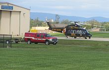
Frederick Municipal Airport (Maryland)
Frederick Municipal Airport | |||||||||||||||
|---|---|---|---|---|---|---|---|---|---|---|---|---|---|---|---|
 Frederick Municipal Airport (FDK) | |||||||||||||||
| Summary | |||||||||||||||
| Airport type | Public | ||||||||||||||
| Owner | City of Frederick | ||||||||||||||
| Location | Frederick, Maryland | ||||||||||||||
| Elevation AMSL | 303 ft / 92 m | ||||||||||||||
| Coordinates | 39°25′03″N 077°22′28″W / 39.41750°N 77.37444°W | ||||||||||||||
| Website | http://www.cityoffrederick.com/index.aspx?nid=152 | ||||||||||||||
 | |||||||||||||||
| Runways | |||||||||||||||
| |||||||||||||||

Frederick Municipal Airport (IATA: FDK, ICAO: KFDK, FAA LID: FDK) is a public airport located in the city of Frederick, in Frederick County, Maryland, United States. This airport is publicly owned by City of Frederick.
Frederick Municipal Airport (FDK) is classified as a general aviation airport. According to analysis, FDK experienced approximately 129,000 operations in 2004 with increases to about 165,000 by 2025.[2]
Facilities
In October 2010, Frederick Municipal Airport received 4.8 million dollars from the American Recovery and Reinvestment Act of 2009 to build and staff a control tower at the airport. Work commenced Oct 2010 and an air traffic control tower, with accompanying Class D airspace, was commissioned May 1, 2012.[3][4][5]
Runways
FDK maintains two paved runways: the primary runway, Runway 5-23, which is 5,220 feet in length and 100 feet in width, and Runway 12-30, which is 3,600 feet in length and 75 feet in width.[1]
Plans for the airfield include upgrading the existing runway 5/23 to 6,000 feet in length, 12/30 to 3,750 feet, and adding a third turf runway with 2,400 feet. In keeping up with increased growth of corporate and personal aircraft in the Frederick area, the airport has also planned for increased hangar storage.[6]
Frederick Municipal Airport currently covers an area of 588 acres (238 ha) and contains two runways:[1]
- Runway 5/23: 5,220 x 100 ft (1,591 x 30 m), Surface: Asphalt
- Runway 12/30: 3,600 x 75 ft (1,097 x 23 m), Surface: Asphalt
On field

- Aircraft Owners and Pilots Association (AOPA) headquarters
- Fuel: 100LL, Jet-A
- Aircraft sales
- Aircraft maintenance
- Oxygen
- Pilot lounge and supplies
- Airways Inn restaurant- Airways Inn
- Flight school and rental- Frederick Flight Center
- Helicopter Flight school and rental- Advanced Helicopter Concepts
Off field
- Fractured Prune Donut Shoppe: 0.5 mi (0.80 km)
- Dutch's Daughter restaurant: 8 mi (13 km)
- Courtyard by Marriott: 5 mi (8.0 km)
- Hampton Inn: 5 mi (8.0 km)
In Popular Culture
The Frederick Municipal Airport, called Frederick Field in the movie, is featured in the 1996 action film Executive Decision starring Kurt Russell, though the airport filmed is not Frederick Municipal Airport.
History
Frederick Municipal Airport was constructed starting on 26 March 1946. The airport opened on 17 April 1946 with the arrival of a Stinson aircraft.[7] The airport became the home of the Experimental Aircraft Association East coast fly-in in 1970.[8]
References
- Airport/Facility Directory published by FAA every 56 days
- US Terminal Procedures published by FAA every 56 days
- Flight Guide published by Airguide Publications, Inc. semiannually
Notes
- ^ a b c FAA Airport Form 5010 for FDK PDF
- ^ City of Frederick (October 11, 2006). "Final report, turf runway report, created" (PDF). www.cityoffrederick.com, accessed 10-25-2011
- ^ Patti S. Borda (September 30, 2010). "Air traffic control tower funding, contract approved". FrederickNewsPost.com, accessed 10-5-2010
- ^ Tripp Laino (February 21, 2012). "Frederick Municipal Airport tower nears opening". FrederickNewsPost.com, accessed 3-8-2012
- ^ AOPA Air Safety Foundation (May 23, 2012). "Frederick Municipal Airport Tower and Class D Airspace". Retrieved 15 June 2012.
{{cite web}}: Unknown parameter|deadurl=ignored (|url-status=suggested) (help) - ^ City of Frederick (October 11, 2006). "Airfield master plan, created" (PDF). www.cityoffrederick.com, accessed 10-25-2011
- ^ "Frederick Municipal Airport". Retrieved 9 April 2012.
- ^ Sport Aviation: 6. March 1971.
{{cite journal}}: Missing or empty|title=(help)
External links
- [1] (official site)
- FAA Airport Diagram (PDF), effective December 26, 2024
- Resources for this airport:
- FAA airport information for FDK
- AirNav airport information for KFDK
- ASN accident history for FDK
- FlightAware airport information and live flight tracker
- NOAA/NWS weather observations: current, past three days
- SkyVector aeronautical chart, Terminal Procedures
