Kalyandurg
Kalyandurg
కళ్యాణ్దుర్గం | |
|---|---|
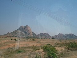
 Akkammagari Konda and surrounding Hills. | |
| Country | India |
| State | Andhra Pradesh |
| District | Anantapur |
| Government | |
| • MLA | Vunnam Hanumantharaya Chowdary[1] |
| Area | |
• Total | 34.92 km2 (13.48 sq mi) |
| Elevation | 656 m (2,152 ft) |
| Population (2011)[4] | |
• Total | 32,328 |
| • Density | 930/km2 (2,400/sq mi) |
| Languages | |
| • Official | Telugu |
| Time zone | UTC+5:30 (IST) |
| Website | Kalyandurg Municipality |
Kalyandurg is a town in Anantapur district of the Indian state of Andhra Pradesh. It is a municipality, mandal headquarters and also the revenue divisional headquarters of Kalyandurg.[5] The discovery of diamond-bearing Kimberlites in Kalyandurg area, is one of the clusters that has been discovered.[6]
History
Boya Palegars ruled important forts of Kalyandurg and rayadurgam. The name of Kalyandurg was derived from the name of a Polygar of 16th Century known as Kalyanappa. Kalyandurgam was under the rule of Sri Krishnadevaraya and was a part of Vijayanagara Empire. Kalyandurg was a taluk of Anantapur district in Madras province which was earlier a part of Dharmavaram that was separated in 1893.[7]
There is a pre-historic habitation at the foot of this rocky hill containing remains of Megalithic-tombs of the usual type and a much larger cubical structure on the hill above.[8]
Sri Subrahmanyeswara Swamy temple is located at the heart of the Town. This temple is built in around 16th century.
Geography
Kalyandurg is located at 14°33′00″N 77°06′00″E / 14.5500°N 77.1000°E.[9] It has an average elevation of 591 metres (1942 ft). The region of Kalyandurg area has is an arid zone with poor stony red soils.[10]
Demographics
As of 2011[update] Census of India, Kalyandurg had a population of 32,328. The total population constitute, 16,036 males and 16,292 females —a sex ratio of 1016 females per 1000 males. 3,404 children are in the age group of 0–6 years, of which 1,760 are boys and 1,644 are girls —a ratio of 979 per 1000. The average literacy rate stands at 74.14% with 21,443 literates, significantly higher than the state average of 67.41%.[4][11]
Governance
Civic administration
The municipality is spread over an area of 15.895 km2 (6.137 sq mi). It has an expenditure of ₹229.29 crore (US$27 million) and generates an annual income of ₹222.87 crore (US$26 million).[12] The municipal body oversees the supply of water with 70 litres per capita per day and in the form 453 public taps, 66 bore–wells. Its other services include maintenance of community halls, secondary and elementary schools and 13.45 km2 (5.19 sq mi) of roads, maternity and child health center such as, Government Hospital, RDT Hospital etc.[13]
Politics
Kalyandurg (Assembly constituency) is one of 14 constituencies in Anantapur district, representing Andhra Pradesh Legislative Assembly. Vunnam Hanumantharaya Chowdary of Telugu Desam Party is the present MLA representing Kalyandurg (Assembly constituency).[1]
See also
References
- ^ a b "MLA's". Official portal of Andhra Pradesh Government. Retrieved 11 September 2014.
- ^ "Municipalities, Municipal Corporations & UDAs" (PDF). Directorate of Town and Country Planning. Government of Andhra Pradesh. Archived from the original (PDF) on 28 January 2016. Retrieved 29 January 2016.
- ^ "Elevation for Katevaram". Veloroutes. Retrieved 11 September 2014.
- ^ a b "Census 2011". The Registrar General & Census Commissioner, India. Retrieved 11 September 2014.
- ^ "Anantapur gets two more revenue divisions". The Hindu. Anantapur. 27 June 2013. Retrieved 10 June 2015.
- ^ "Discovery of diamond-bearing kimberlites in Kalyandurg area, Anantapur district, Andhra Pradesh". Indian Institute of Science, Bangalore. Retrieved 11 September 2014.
- ^ Prem Loganathan. "Boyar mudiraja". The Great Boyar Valmiki Nayaka Emperors. bedar.nayaka.in. Retrieved 12 September 2014.
- ^ http://asihyd.ap.nic.in/anantapur_gooty.html
- ^ Kalyandurg at Fallingrain.com
- ^ "Region geography" (PDF). shodhganga. p. 48. Retrieved 12 September 2014.
- ^ "Literacy of AP (Census 2011)" (PDF). Official Portal of Andhra Pradesh Government. p. 43. Retrieved 11 September 2014.
- ^ "Basic Information of Municipality". Commissioner & Director of Municipal Administration. Municipal Administration & Urban Development Department, Govt. of Andhra Pradesh. Retrieved 11 September 2014.
- ^ "Public services/amenities". Commissioner & Director of Municipal Administration. Municipal Administration & Urban Development Department, Govt. of Andhra Pradesh. Retrieved 11 September 2014.
