Si-o-se-pol
Si-o-se Pol | |
|---|---|
 | |
| Coordinates | 32°38′40″N 51°40′03″E / 32.64444°N 51.66750°E |
| Crosses | Zayandeh River[1] |
| Locale | Isfahan, Iran |
| Official name | Si-o-se Pol |
| Characteristics | |
| Design | Arch bridge, double-deck[1] |
| Material | Stone and Bricks[1] |
| Total length | 297.76 metres (976.9 ft)[1] |
| Width | 13.75 metres (45.1 ft)[1] |
| Longest span | 5.60 metres (18.4 ft)[1] |
| No. of spans | 33[1] |
| History | |
| Construction start | 1599[1] |
| Construction end | 1602[1] |
| Location | |
 | |
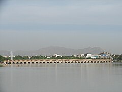
Allāhverdi Khan Bridge (Template:Lang-fa), popularly known as Si-o-seh pol (Template:Lang-fa; [ˈsiː oˈseh ˈpol], “The bridge of thirty-three spans”)[2] is one of the eleven bridges of Isfahan, Iran and the longest bridge on Zayandeh River with the total length of 297.76 metres (976.9 ft). It is highly ranked as being one of the most famous examples of Safavid bridge design.
It was constructed by the finance and the inspection of Allahverdi Khan Undiladze chancellor of Shah Abbas I, an ethnic Georgian, it consists of two rows of 33 arches from either sides, left and right. There is a larger base plank at the start of the bridge where the Zayandeh River flows under it, supporting a tea house which nowadays is abandoned due to the shortage of water and the river drought due to government mismanagement.
Image gallery
-
Inner view
-
33 Pol night view
-
The whole view of 33 Pol at night
-
A view of the whole bridge
-
One of the bridges from top
Transportation
 Chahar Bagh Abbasi Street
 Motahari Street
 Kamaloddin Esmaeil Street
 Chahar Bagh Bala Street
 Mellat Street
 Ayenekhaneh Street
 Enqelab Metro Station
 Si-o-se Pol Station
Notes
- ^ a b c d e f g h i Allahverdi Khan Bridge at Structurae
- ^ Babaie, Sussan; Haug, Robert (April 5, 2012) [December 15, 2007]. "Isfahan x. Monuments (5) Bridges". In Yarshater, Ehsan (ed.). Encyclopædia Iranica. 1. Vol. XIV. New York City: Bibliotheca Persica Press. Retrieved September 25, 2015.
References
- About Si-o-Seh Pol
- Wagret, Paul (1977). Iran. Nagel's encyclopedia-guide. Geneva: Nagel Publishers. ISBN 2-8263-0026-1.
{{cite book}}: Cite has empty unknown parameter:|coauthors=(help) - More Pictures,Tishineh


