Clarin, Bohol
Appearance
Clarin | |
|---|---|
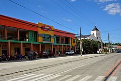
 Clarin – market and church (new 2016) | |
 Map of Bohol with Clarin highlighted | |
| Coordinates: 9°58′N 124°01′E / 9.97°N 124.02°E | |
| Country | Philippines |
| Region | Central Visayas (Region VII) |
| Province | Bohol |
| District | 2nd district of Bohol |
| Organized | 31 January 1919 |
| Barangay | Template:PH barangay parts |
| Government | |
| • Type | Sangguniang Bayan |
| • Mayor | Allen Piezas (LP) |
| • Vice mayor | Velden Aparicio |
| • Municipal Council | Members |
| • Representative | Erico Aristotle Aumentado |
| Area | |
• Total | 52.12 km2 (20.12 sq mi) |
| Population (2020 census)[3] | |
• Total | 21,158 |
| • Density | 410/km2 (1,100/sq mi) |
| • Voter (2022)[4] | 16,375 |
| • Language | Boholano dialect Cebuano Tagalog |
| Time zone | UTC+8 (PST) |
| ZIP code | 6330 |
| IDD : area code | +63 (0)38 |
| Income class | 5th class |
| PSGC | 071214000 |
Clarin is a [[Template:PH plural of the Philippines#Income classification|5th municipal income class municipality]] in the province of Bohol, Philippines,[2] located 61 km (38 mi) from Tagbilaran. According to the 2020 census, it has a population of 21,158.[3] Template:PH electorate
Geography
- 2013 Bohol earthquake
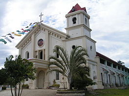
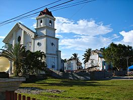
Clarin was severely affected by the 2013 Bohol earthquake which damaged 1358 homes, of which 221 were totally destroyed, as well as the Catholic church.[5]
-
Roman Catholic Church before earthquake
-
Roman Catholic Church after earthquake
Barangays
Clarin comprises 24 barangays:
| PSGC | Barangay | Population | ±% p.a. | |||
|---|---|---|---|---|---|---|
| 2020[3] | 2010[6] | |||||
| 071214001 | Bacani | 5.6% | 1,185 | 1,208 | −0.19% | |
| 071214002 | Bogtongbod | 6.7% | 1,428 | 1,377 | 0.36% | |
| 071214003 | Bonbon | 6.7% | 1,427 | 1,487 | −0.41% | |
| 071214004 | Bontud | 2.3% | 497 | 456 | 0.86% | |
| 071214005 | Buacao | 3.0% | 644 | 797 | −2.11% | |
| 071214006 | Buangan | 3.9% | 824 | 796 | 0.35% | |
| 071214007 | Cabog | 3.9% | 829 | 764 | 0.82% | |
| 071214008 | Caboy | 2.7% | 569 | 571 | −0.04% | |
| 071214009 | Caluwasan | 1.2% | 255 | 222 | 1.40% | |
| 071214010 | Candajec | 5.0% | 1,061 | 932 | 1.30% | |
| 071214011 | Cantoyoc | 1.6% | 346 | 343 | 0.09% | |
| 071214012 | Comaang | 2.4% | 498 | 471 | 0.56% | |
| 071214013 | Danahao | 3.3% | 693 | 856 | −2.09% | |
| 071214014 | Katipunan | 1.4% | 301 | 340 | −1.21% | |
| 071214015 | Lajog | 6.0% | 1,262 | 1,381 | −0.90% | |
| 071214016 | Mataub | 3.0% | 632 | 700 | −1.02% | |
| 071214017 | Nahawan | 10.4% | 2,202 | 2,208 | −0.03% | |
| 071214018 | Poblacion Centro | 6.1% | 1,285 | 1,234 | 0.41% | |
| 071214019 | Poblacion Norte | 3.9% | 831 | 838 | −0.08% | |
| 071214020 | Poblacion Sur | 5.9% | 1,246 | 1,159 | 0.73% | |
| 071214021 | Tangaran | 3.7% | 776 | 850 | −0.91% | |
| 071214022 | Tontunan | 2.8% | 593 | 559 | 0.59% | |
| 071214023 | Tubod | 2.3% | 484 | 402 | 1.87% | |
| 071214024 | Villaflor | 2.0% | 423 | 345 | 2.06% | |
| Total | 21,158 | 20,296 | 0.42% | |||
Demographics
|
| ||||||||||||||||||||||||
| Source: Philippine Statistics Office[7][6][8] | |||||||||||||||||||||||||
Education
Elementary and primary schools
-
- Bacani Elementary School
- Bogtongbod Elementary School
- Bonbon Elementary School
- Buacao Primary School
- Buangan Elementary School
- Buntod Primary School
- Caboy Elementary School
- Clarin Central Elementary School
- Danahaw Elementary School
- Lajog Elementary School
- Nahawan Elementary School
- Tontunan Elementary School
Secondary schools
-
- Clarin National School of Fisheries
- Nahawan High School
Tertiary schools
References
- ^ Municipality of Clarin | (DILG)
- ^ a b "Municipal: Clarin, Bohol". PSGC Interactive. Quezon City, Philippines: Philippine Statistics Authority. Retrieved 8 January 2016.
- ^ a b c Census of Population (2020). "Region VII (Central Visayas)". Total Population by Province, City, Municipality and Barangay. Philippine Statistics Authority. Retrieved 8 July 2021.
- ^ "Number of Registered Voters by Sex : 2019 National and Local Elections" (PDF). Commission on Elections. 2019.
- ^ "SitRep No. 35 re Effects of Magnitude 7.2 Sagbayan, Bohol Earthquake" (PDF). National Disaster Risk Reduction and Management Council. November 3, 2013. Retrieved December 17, 2013.
{{cite web}}: Italic or bold markup not allowed in:|publisher=(help) - ^ a b Census of Population and Housing (2010). "Region VII (Central Visayas)" (PDF). Total Population by Province, City, Municipality and Barangay. National Statistics Office. Retrieved 29 June 2016.
- ^ Census of Population (2015). "Region VII (Central Visayas)". Total Population by Province, City, Municipality and Barangay. Philippine Statistics Authority. Retrieved 20 June 2016.
- ^ Censuses of Population (1903–2007). "Region VII (Central Visayas)". Table 1. Population Enumerated in Various Censuses by Province/Highly Urbanized City: 1903 to 2007. National Statistics Office.
Wikimedia Commons has media related to Clarin.


