Rhayader
Cite error: There are <ref> tags on this page without content in them (see the help page).Cite error: There are <ref> tags on this page without content in them (see the help page).
Rhayader
| |
|---|---|
 | |
Location within Powys | |
| Population | 2,088 (2011) |
| OS grid reference | SN975685 |
| Principal area | |
| Preserved county |
|
| Country | Wales |
| Sovereign state | United Kingdom |
| Post town | RHAYADER |
| Postcode district | LD6 |
| Dialling code | 01597 |
| Police | Dyfed-Powys |
| Fire | Mid and West Wales |
| Ambulance | Welsh |
| UK Parliament | |
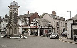
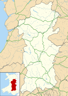
Rhayader (/ˈreɪ.ədər/; Template:Lang-cy pronounced [ˈr̥əɪadar ˈɡʊi̯]) is a market town and community in Powys, Wales. It has a population of 2,088,[1] and is the first town on the banks of the River Wye, 20 miles (32 km) from its source on the Plynlimon range of the Cambrian Mountains.
Although being situated in the mostly Anglicised border county of Radnorshire, 55% of the community have some form of Welsh identity according to the 2011 census.[2]
The town is one of the principal centres of population in the historic county of Radnorshire.
It is situated roughly midway between North and south Wales on the A470, 13 miles north of Builth Wells and 30 miles east of Aberystwyth on the A44 - two of Wales' most important trunk roads. The B4574 mountain road to Aberystwyth is described by the AA as one of the ten most scenic drives in the world.[3][4]
Etymology
The name "Rhayader" is a partly-Englished form of its Welsh name "Y Rhaeadr" (the waterfall), or more fully, "Rhaeadr Gwy" (waterfall [on the] Wye). Strictly speaking, according to place-name spelling conventions in Welsh, the name of the town would be 'Rhaeadr-gwy', and the waterfall itself 'Rhaeadr Gwy', but it seems that this distinction is usually ignored. In the Welsh of the area the name is, as one would expect on the pattern of similar words, Rheiad pronounced [ˈr̥əɪad] [5]. Little remains of the waterfall itself, it having been destroyed in 1780 to make way for the bridge linking the town to Cwmdauddwr and the Elan Valley - the Lakeland of Wales.
History

The abundance of cairns and standing stones bears witness that man inhabited the area several thousand years BCE. An important hoard of gold jewellery dating from 1st-2nd centuries AD was found in 1899 in the vicinity of the town. Known as the Rhayader Hoard, it is now in the Roman-British collection of the British Museum.[6][7] Rhayader has always been a natural stopping point for travellers - the Romans had a stop-over camp in the Elan Valley, Monks travelled between the Abbeys of Strata Florida and Abbeycwmhir and drovers headed to the lucrative markets with their livestock.[8] it wasn't until the 12th Century that documented history of the town began with the building of a Castle in 1177. Little remains today, with the exception of a dry moat that can be seen from Wauncapel Park.[8]
One of the oldest buildings in Rhayader is the Old Swan, which stands on the corner of West and South Streets Rhayader. The original building was mentioned in 1676 as being one of the two inns in Rhayader at that date. Some changes were made in 1683, including the rebuilding of the three chimney stacks, and this date is carved into the old timbers inside the building.
In the 19th Century, turnpike roads were only passable on payment of extortionate tolls, imposing additional burdens on already poor communities. This led to the Rebecca Riots across South and Mid Wales from 1839–1842, with no less than six of Rhayader's tollgates being demolished with impunity by local farmers dressed as women. The actions of these 'Rebeccaites' led to a Commission of Inquiry being set up, and most of Rebecca's grievances were righted two years later.[9]
In the 1890s the rapidly expanding city of Birmingham, 70 miles east, viewed the nearby Elan Valley as the ideal source of clean, safe water. This was to change the face of Rhayader forever, bringing thousands of workers involved in building this massive complex of dams and reservoirs to the area. A new railway was built connecting this huge area with the main network in Rhayader, and the construction of a new village to house the workers was built on the banks of the River Elan. Work started in 1894 and the scheme was officially opened in 1904 by King Edward VII and Queen Alexandra.[8][10]
Transport
The station on the Mid Wales Railway line that served the town was closed on 31 December 1962. The nearest station is now at Crossgates on the Heart of Wales Line, though connections are usually made at the more accessible Llandrindod railway station a similar distance away.
An extensive bus service connects with outlying villages and neighbouring towns, with two-hourly daytime departures to Builth Wells, Llandrindod Wells, Aberystwyth and Newtown, with connections to Hereford, Shrewsbury, Cardiff and further afield.
Due to the volume of traffic generated by the convergence of two of Wales's most important trunk roads, the construction of a bypass to relieve congestion at the town centre crossroads has been an ongoing debate for many years.[11]
The town is also a popular cycling centre and is on Route 8 of the United Kingdom National Cycle Network - Lôn Las Cymru.
Amenities
Tourism and agriculture are the most important industries locally. Walkers and cyclists are drawn to Rhayader for the abundance of trails and bridleways surrounding the town, which is the gateway to a massive complex of reservoirs and dams (The Elan Valley). This vast area is home to some of Britain's rarest wildlife and plants, including red kites, along with magnificent feats of engineering.
There are a number of hotels, bed and breakfasts and campsites to accommodate the large amount of visitors that travel to the area all year round.
Rhayader is also home to a community founded art and heritage complex which includes a museum and gallery,[12] a leisure centre, numerous parks and all the amenities expected of a larger town. There are an abundance of shops, banks, restaurants, takeaways and supermarkets catering to both the local population and visitors to the area.
Rhayader is also renowned for being the town with the highest concentration of pubs and drinking establishments, per capita, in the UK, with one to each 173 people.[13]
In nearby Nantmel, across the river Wye from the village of Llanwrthwl, the Living Willow Theatre, an open-air theatre constructed of living willow trees, was opened in 2007.
Sport
Rhayader Town F.C., despite previously having some success in the League of Wales - the top-tier of domestic Welsh football between 1997 and 2002, ceased to exist in the summer of 2006. The club has since reformed, and in its inaugural season gained promotion into the Spar Mid Wales League.[14] A subsequent promotion to the Cymru Alliance followed, but a finishing position of 15th saw the team relegated after just one season. The town's rugby union team play in the Cambrian Training Mid Wales League. There is also a cricket club and thriving local darts, dominos and pool leagues.
The town is also well known by motocross fans. Every summer a series of events take place at the nearby Cwmythig Hill circuit, with many of Britain's top riders taking part. The race series regularly attracts over 5,000 spectators.
As part of the annual carnival celebrations, Rhayader also plays host to a number of World Championship events in lesser celebrated sports, including wheelbarrow racing and rock-paper-scissors.
Town Development
Rhayader and its surrounding districts are supported by Development Organisation Rhayader 2000 Ltd. Established in March 1995, Rhayader 2000 Ltd is a voluntary sector, community development organisation representing a cross section of the local community. Strong links have been created with Powys County Council, Rhayader Town Council, local businesses, a selection of charitable and voluntary organisations and the local community, to enable a variety of initiatives to be undertaken which have had a real and lasting impact on the life of the town.
Rhayader 2000 manages the town's website: www.rhayader.co.uk
References
- ^ Powys County Council : Census 2011 : Rhayader Community Retrieved 13 November 2010
- ^ "rhayader identity". neighbourhood.statistics.gov.uk. Retrieved 16 May 2016.
- ^ "Cycling Breaks UK - Cycling in the UK at Visit Wales". Cycling.visitwales.com. Retrieved 24 April 2013.
- ^ Rachael Misstear (11 April 2009). "PM should head West for a 'hidden gem' holiday destination". Wales Online. Retrieved 24 April 2013.
- ^ "Hen Ffrwcsod Ffair-rhos – Mary Thomas (1905-83)". Amgueddfa Cymru. Retrieved 30 May 2017.
- ^ British Museum Collection
- ^ BBC report
- ^ a b c "About". Rhayader. Retrieved 24 April 2013.
- ^ http://history.powys.org.uk/school1/rhayader/origins.shtml
- ^ http://history.powys.org.uk/school1/rhayader/elanmenu.shtml
- ^ "Shropshire Star". Shropshire Star. Retrieved 24 April 2013.
- ^ Rhayader Museum and Gallery CARAD , 'The Organisation', http://carad.org.uk/about/organisation [accessed 24 January 2014]
- ^ "Town has pub for every 173 people". London: BBC. 28 May 2008.
- ^ "Rhayader Town secure promotion to Spar". County Times. 1 May 2008.


