Parliamentary constituencies in Gloucestershire
The county of Gloucestershire is divided into 6 Parliamentary constituencies - 2 Borough constituencies and 4 County constituencies.
Constituencies
† Conservative ‡ Labour ¤ Liberal Democrat
| Constituency[nb 1] | Electorate[1] | Majority[nb 2] | Member of Parliament | Nearest opposition | Electoral wards[2][3] | Map | ||
|---|---|---|---|---|---|---|---|---|
| Cheltenham BC | 77,286 | 6,516 | bgcolor=Template:Conservative Party (UK)/meta/color| | Alex Chalk | bgcolor=Template:Liberal Democrats (UK)/meta/color| | Martin Horwood¤ | Cheltenham Borough Council: All Saints, Battledown, Benhall and The Reddings, Charlton Kings, Charlton Park, College, Hesters Way, Lansdown, Leckhampton, Oakley, Park, Pittville, St Mark’s, St Paul’s, St Peter’s, Springbank, Up Hatherley, Warden Hill. |  |
| Forest of Dean CC | 69,865 | 10,987 | bgcolor=Template:Conservative Party (UK)/meta/color| | Mark Harper† | bgcolor=Template:Labour Party (UK)/meta/color| | Steve Parry-Hearn | Forest of Dean District Council: Alvington, Aylburton and West Lydney, Awre, Berry Hill, Blaisdon and Longhope, Bream, Bromesberrow and Dymock, Christchurch and English Bicknor, Churcham and Huntley, Cinderford East, Cinderford West, Coleford Central, Coleford East, Hartpury, Hewelsfield and Woolaston, Littledean and Ruspidge, Lydbrook and Ruardean, Lydney East, Lydney North, Mitcheldean and Drybrook, Newent Central, Newland and St Briavels, Newnham and Westbury, Oxenhall and Newent North East, Pillowell, Redmarley, Tibberton, Tidenham. Tewkesbury Borough Council: Highnam with Haw Bridge. |  |
| Gloucester BC | 82,964 | 7,241 | bgcolor=Template:Conservative Party (UK)/meta/color| | Richard Graham† | bgcolor=Template:Labour Party (UK)/meta/color| | Sophy Gardner | Gloucester City Council: Abbey, Barnwood, Barton and Tredworth, Elmbridge, Grange, Hucclecote, Kingsholm and Wotton, Matson and Robinswood, Moreland, Podsmead, Quedgeley Fieldcourt, Quedgeley Severn Vale, Tuffley, Westgate. |  |
| Stroud CC | 80,544 | 4,866 | bgcolor=Template:Conservative Party (UK)/meta/color| | Neil Carmichael† | bgcolor=Template:Labour Party (UK)/meta/color| | David Drew‡ | Stroud District Council: Amberley and Woodchester, Berkeley, Bisley, Cainscross, Cam East, Cam West, Central, Chalford, Coaley and Uley, Dursley, Eastington and Standish, Farmhill and Paganhill, Hardwicke, Nailsworth, Over Stroud, Painswick, Rodborough, Severn, Slade, Stonehouse, The Stanleys, Thrupp, Trinity, Uplands, Upton St Leonards, Vale, Valley. |  |
| Tewkesbury CC | 78,910 | 21,972 | bgcolor=Template:Conservative Party (UK)/meta/color| | Laurence Robertson† | bgcolor=Template:Labour Party (UK)/meta/color| | Ed Buxton | Cheltenham Borough Council: Prestbury, Swindon Village. Gloucester City Council: Longlevens. Tewkesbury Borough Council: Ashchurch with Walton Cardiff, Badgeworth, Brockworth, Churchdown Brookfield, Churchdown St John’s, Cleeve Grange, Cleeve Hill, Cleeve St Michael’s, Cleeve West, Coombe Hill, Hucclecote, Innsworth with Down Hatherley, Isbourne, Northway, Oxenton Hill, Shurdington, Tewkesbury Newtown,
Tewkesbury Prior’s Park, Tewkesbury Town With Mitton, Twyning, Winchcombe. |
 |
| The Cotswolds CC | 78,291 | 21,477 | bgcolor=Template:Conservative Party (UK)/meta/color| | Geoffrey Clifton-Brown† | bgcolor=Template:Liberal Democrats (UK)/meta/color| | Paul Hodgkinson | Cotswold District Council: Ampney-Coln, Avening, Beacon-Stow, Blockley, Bourton-on-the-Water, Campden-Vale, Chedworth, Churn Valley, Cirencester Beeches, Cirencester Chesterton, Cirencester Park, Cirencester Stratton-Whiteway, Cirencester Watermoor, Ermin, Fairford, Fosseridge, Grumbolds Ash, Hampton, Kempsford-Lechlade, Moreton-in-Marsh, Northleach, Rissingtons, Riversmeet, Sandywell, Tetbury, Thames Head, Three Rivers, Water Park. Stroud District Council: Kingswood, Minchinhampton, Wotton-under-Edge. |  |
Boundary changes
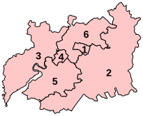
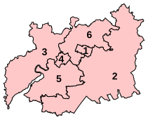
Current proposals by the Boundary Commission for England would retain these 6 constituencies, with changes to realign constituency boundaries with the boundaries of current local government wards, and to reduce the electoral disparity between constituencies. Although the changes are small, the expanded Cotswold constituency will be called The Cotswolds. These changes will be implemented at the United Kingdom general election, 2010.
| Name | Pre-2010 Boundaries | Post-2010 Boundaries |
|---|---|---|
 |
 |
Results
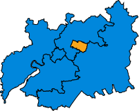
| 2005 | 2010 | 2015 |
|---|---|---|

|

|

|
See also
List of Parliamentary constituencies in Avon for divisions in South Gloucestershire and Bristol.
Historical representation by party
1885 to 1918
Conservative Liberal Liberal Unionist
1918 to 1950
Coalition Liberal (1918-22) / National Liberal (1922-23) Conservative Independent Conservative Independent Labour Independent National Labour Liberal National Labour National Liberal (1931-68)
1950 to 1983
Conservative Labour National Liberal (1931-68) Speaker
1983 to present
Conservative Labour Liberal Democrats
Graphical representation
| style="background:Template:Labour Party (UK)/meta/color; width:21%;" | 21.0% | style="background:Template:Liberal Democrats/meta/color; width:28.7%;" | 28.7% | 5.5% | style="background:Template:Conservative Party (UK)/meta/color; width:44.8%;" | 44.8% |
| Labour | Lib Dems | Others | Conservative |
| style="background:Template:Green Party (UK)/meta/color; width:4.4%;" | 4.4% | style="background:Template:Labour Party (UK)/meta/color; width:21%;" | 21.0% | style="background:Template:Liberal Democrats/meta/color; width:13.4%;" | 13.4% | style="background:Template:Official Monster Raving Loony Party/meta/color; width:0.1%;" | | style="background:Template:Independent (politician)/meta/color; width:0.2%;" | | style="background:Template:Conservative Party (UK)/meta/color; width:49.2%;" | 49.2% | style="background:Template:UK Independence Party/meta/color; width:11.6%;" | 11.6% |
| Grn | Labour | Lib Dems | Conservative | UKIP |
Notes
References
- ^ http://geo.digiminster.com/election/2015-05-07/Search?Query=Gloucestershire
- ^ "The Parliamentary Constituencies (England) Order 2007, page 4". Office of Public Sector Information. Crown copyright. 13 June 2007. Retrieved 7 November 2009.
- ^ Boundary Commission for England pp. 1004–1007
