Central Lawrenceville
Central Lawrenceville | |
|---|---|
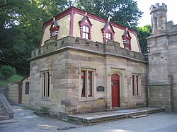
 Butler Street Gatehouse of Allegheny Cemetery | |
 | |
| Coordinates: 40°28′19″N 79°57′32″W / 40.472°N 79.959°W | |
| Country | United States |
| State | Pennsylvania |
| County | Allegheny County |
| City | Pittsburgh |
| Area | |
• Total | 0.963 sq mi (2.49 km2) |
| Population (2010)[1] | |
• Total | 4,482 |
| • Density | 4,700/sq mi (1,800/km2) |
| ZIP Code | 15201 |
Central Lawrenceville is a neighborhood in the northeast of Pittsburgh, Pennsylvania in the United States. It has a zip code of 15201, and has representation on Pittsburgh City Council by the council member for District 7 (North Central East Neighborhoods). It is home to Allegheny Cemetery. Central Lawrenceville is the home of the Pittsburgh Bureau of Fire's 6 Engine and 6 Truck.
Surrounding and adjacent neighborhoods
Central Lawrenceville has five land borders with the Pittsburgh neighborhoods of Upper Lawrenceville to the north, Stanton Heights to the east and northeast, Garfield to the southeast, Bloomfield to the south, and Lower Lawrenceville to the southwest. Across the Allegheny River to the northwest, Central Lawrenceville runs adjacent with Millvale (with a direct connector via 40th Street Bridge) and Shaler Township.
References
- ^ a b "PGHSNAP 2010 Raw Census Data by Neighborhood". Pittsburgh Department of City Planning PGHSNAP Utility. 2012. Retrieved 21 June 2013.
{{cite news}}: External link in|publisher=
Further reading
- Toker, Franklin (1994) [1986]. Pittsburgh: An Urban Portrait. Pittsburgh: University of Pittsburgh Press. ISBN 0-8229-5434-6.
External links
See also
