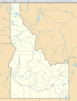
Dixie, Idaho County, Idaho
Appearance
Dixie, Idaho | |
|---|---|
| Coordinates: 45°33′15″N 115°27′40″W / 45.55417°N 115.46111°W | |
| Country | United States |
| State | Idaho |
| County | Idaho |
| Elevation | 5,620 ft (1,710 m) |
| Time zone | UTC-8 (Pacific (PST)) |
| • Summer (DST) | UTC-7 (PDT) |
| Area code | 208 |
| GNIS feature ID | 1802953[1] |
Dixie is an unincorporated community in Idaho County, Idaho, United States, located 43 miles (69 km) east-northeast of Riggins. Dixie was an important gateway to the Thunder Mountain Mines of Idaho during the early 1900's when Dixie was on the northern terminus of the Three Blaze Trail, a shortcut route to the mines via Campbell's Ferry, and what is now the Frank Church-River of No Return Wilderness, Chamberlain Basin, and southward to the mining community of Roosevelt, located on Monumental Creek.
Climate
Dixie has a dry summer continental subarctic climate (Dsc) according to the Köppen climate classification system.
| Climate data for Dixie (1952-2011) | |||||||||||||
|---|---|---|---|---|---|---|---|---|---|---|---|---|---|
| Month | Jan | Feb | Mar | Apr | May | Jun | Jul | Aug | Sep | Oct | Nov | Dec | Year |
| Record high °F (°C) | 54 (12) |
59 (15) |
64 (18) |
78 (26) |
86 (30) |
88 (31) |
96 (36) |
99 (37) |
93 (34) |
80 (27) |
64 (18) |
53 (12) |
99 (37) |
| Mean daily maximum °F (°C) | 30.8 (−0.7) |
35.4 (1.9) |
39.9 (4.4) |
46.6 (8.1) |
56.7 (13.7) |
65.9 (18.8) |
76.4 (24.7) |
75.9 (24.4) |
66.6 (19.2) |
53.8 (12.1) |
38.2 (3.4) |
31.1 (−0.5) |
51.4 (10.8) |
| Mean daily minimum °F (°C) | 4.8 (−15.1) |
7.1 (−13.8) |
12.8 (−10.7) |
21.1 (−6.1) |
28.7 (−1.8) |
34.8 (1.6) |
37.4 (3.0) |
35.1 (1.7) |
28.9 (−1.7) |
22.8 (−5.1) |
14.1 (−9.9) |
5.8 (−14.6) |
21.1 (−6.1) |
| Record low °F (°C) | −42 (−41) |
−42 (−41) |
−36 (−38) |
−9 (−23) |
4 (−16) |
19 (−7) |
23 (−5) |
19 (−7) |
9 (−13) |
−13 (−25) |
−35 (−37) |
−49 (−45) |
−49 (−45) |
| Average precipitation inches (mm) | 3.55 (90) |
2.55 (65) |
2.64 (67) |
2.24 (57) |
2.44 (62) |
2.51 (64) |
1.09 (28) |
1.3 (33) |
1.41 (36) |
1.88 (48) |
3.17 (81) |
3.5 (89) |
28.27 (718) |
| Average snowfall inches (cm) | 42.6 (108) |
29.7 (75) |
28.4 (72) |
15.9 (40) |
5.1 (13) |
0.6 (1.5) |
0 (0) |
0 (0) |
0.9 (2.3) |
5 (13) |
28.9 (73) |
41 (100) |
198.1 (503) |
| Average precipitation days | 15 | 12 | 13 | 12 | 12 | 10 | 5 | 6 | 6 | 8 | 13 | 15 | 127 |
| Source: WRCC[2] | |||||||||||||
Transportation
Airports
The following public-use airports are located near Dixie
- Dixie USFS Airport (A05)
- Wilson Bar USFS Airport (C48)
References
- ^ "US Board on Geographic Names". United States Geological Survey. 2007-10-25. Retrieved 2008-01-31.
- ^ "DIXIE, ID (102575)". Western Regional Climate Center. Retrieved November 26, 2015.


