Jeongseon County
Jeongseon
정선군 | |
|---|---|
| Korean transcription(s) | |
| • Hangul | 정선군 |
| • Hanja | 旌善郡 |
| • Revised Romanization | Jeongseon-gun |
| • McCune-Reischauer | Chŏngsŏn-gun |
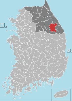
 Location in South Korea | |
| Country | |
| Region | Gwandong |
| Province | Gangwon-do |
| Administrative divisions | 4 eup, 5 myeon |
| Area | |
• Total | 1,220.67 km2 (471.30 sq mi) |
| Population (2004) | |
• Total | 46,362 |
| • Density | 38/km2 (100/sq mi) |
| • Dialect | Gangwon |
Jeongseon (Jeongseon-gun) is a county in the province of Gangwon-do, South Korea. It is famous as the hometown of "Jeongseon Arirang," a traditional Korean folksong. It is also the hometown of actor Won Bin and footballer Seol Ki-hyeon.
History
It was ruled by the Goguryeo Dynasty during the Three Kingdoms period, called Ingpyae-hyeon (잉패현). After the Silla Dynasty unified the Korean peninsula, it was renamed Jeongseon-hyeon in 757. After the Goryeo Dynasy was founded, it was promoted from a hyeon to a county (gun) in 1012 or 1018.[1]
After the Joseon Dynasty was founded and the territory was divided into 8 Provinces, the region was involved in the province of Gangwon.[2] After the territory was divided into 23 districts in 1895 with the 8-provincial system abolished, it was included in the district of Chugju. When a 13-provincial system was enacted in 1896, it returned to Gangwon Province.[3]
Administrative divisions
Towns (eup)
Townships (myeon)
Geography
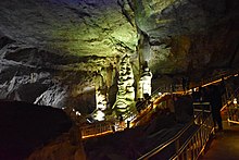
A lot of coal and limestone is buried in the strata formed during the Paleozoic Era in this region. A Karst zone formed from the dissolution of the limestone is located, and many of solutional caves are found.[4]
Natural monuments shaped from the limestone are as follows.
- Baekbongryeong Karst zone: Karst zone in baekbongryeong zone is known to be academically useful because karst is located in small area. It was designated Natural Monuments of South korea number 440 on April 9, 2004.[5]
- Jeongseon coral cave: few stony corals are growing in the cave, and there is big coral which is not found elsewhere. Designated as natural monuments number 509 on December 15, 2009.[6]
Culture and tourism


Cultural heritages
There are one treasure, 6 natural monuments, 1 important folklore cultural heritage in Jeongseon. Province designated 3 tangible cultural heritages, 1 intagible cultural heritage, 5 monumnets, 2 folklore heritages.[7][8]
Temple
- Jeongamsa Temple : Founded by Jajang, also known as "Galaesa". As Sumano Pagoda stores buddha's Śarīra, there is no Buddharupa.[9]
- Sumano Pagoda in Jeongamsa Temple: Pagoda in Jeongamsa Temple. Stones are sharpen like a brick. Designated as Treasure number 410. It is assumed that it was constructured during the Goryeo Dynasty, considering other heritages found in the Jeongam temple. Records indicate it was repaired in 1653.[10]
Natural Heritages
- Brachymystax lenok habitat: Korean Peninsula is in the southern limit of Brachymystax lenok habitat, thus academic importance is recognized and habitat is registered as natural monuments of South Korea on December 7, 1962.[11]
- Banronsan Rhododendron schlippenbachii and Chwinamul habitat: Banronsan's rhododendron schlippenbachii is the biggest in South Korea's known rhododendron schlippenbachii, and Chwinamul is protected because it is locally grown. It was designated Natural Monuments of South Korea number 348 on April 17, 1986.[12]
- Duwibong Taxus cuspidata habitat: Taxus cuspidata in Duwibong is protected becauase it is considered oldest in South Korea. Designated natural monuments of South Korea on June 29, 2004 as number 433.[13]
Tourism
High 1 Resort, a ski resort, is located in Gohan-eup, the resort at 1,345 meters is at the highest altitude of the Korean ski resorts.[14] Kangwon Land, the only domestic casino that is open to South Korean citizens, is also located nearby.[15]
Arirang Museum, run by the county government, was opened in 2016 to promote Arirang, collecting and displaying around 600 exhibits.[16][17]
Jeongseon Arirang Festival is held annually in October, to preserve Jeongseon Arirang and promote them. In addition to Jeongseon Arirang show, Arirang from other region is also performed.[18]
Sports
2018 Winter Olympic Games
The Alpine Skiing venue was located at the Jeongseon Alpine Centre in Jungbong, Bukpyeong-myeon, Jeongseon during the 2018 Winter Olympics.
Transportation

Taebaek line and Jeongseon line pass through Jeongseon county. A-train departing from Cheongnyangni operates to Auraji. There is no highway in Jeongseon County, but Yeongdong Expressway is accessible through Pyeongchang County, and national highway number 6, 31, 35, 42, 49 passes through the County.[19]
See also
References
- ^ 글로벌세계대백과사전. 범한.
- ^ "강원도 역사와 문화". www.provin.gangwon.kr. Archived from the original on 2014-06-01.
{{cite web}}: Unknown parameter|deadurl=ignored (|url-status=suggested) (help) - ^ "History". jeongseon.go.kr. Archived from the original on 2018-02-20.
{{cite web}}: Unknown parameter|deadurl=ignored (|url-status=suggested) (help) - ^ 국토지리정보원 (2015). 한국지리지 강원도. p. 389.
- ^ "정선 백봉령 카르스트 지대". 국가문화유산포털 (in Korean). 문화재청. Retrieved 2018-02-21.
- ^ "정선 산호동굴". 국가문화유산포털 (in Korean). 문화재청. Retrieved 2018-02-21.
- ^ "우리지역 문화재" [Heritages in your region]. Cultural Heritage Administration (in Korean). 2018-02-13. Retrieved 2018-02-13.
{{cite web}}: Unknown parameter|authors=ignored (help) - ^ "정선 관광문화:보물" [Jeongseon Culture Tour : Treasures]. Jeongseon Tour (in Korean). 2018-02-13. Archived from the original on 2018-02-10. Retrieved 2018-02-13.
{{cite web}}: Unknown parameter|authors=ignored (help); Unknown parameter|deadurl=ignored (|url-status=suggested) (help) - ^ "정암사" [Jeongamsa]. 한국민족문화대백과사전 (in Korean). 한국학중앙연구원. 1996. Archived from the original on 2018-02-20. Retrieved 2018-02-20.
{{cite encyclopedia}}: Unknown parameter|deadurl=ignored (|url-status=suggested) (help) - ^ Jeong, Yeongho (1996). "수마노탑" [Sumano Pagoda]. 한국민족문화대백과사전. 한국학중앙연구원. Archived from the original on 2018-02-20. Retrieved 2018-02-20.
{{cite encyclopedia}}: Unknown parameter|deadurl=ignored (|url-status=suggested) (help) - ^ "정선 정암사 열목어 서식지". 국가문화유산포털 (in Korean). 문화재청. Retrieved 2018-02-21.
- ^ "정선 반론산 철쭉나무 및 분취류 자생지". 국가문화유산포털 (in Korean). 문화재청. Retrieved 2018-02-21.
- ^ "정선 두위봉 주목". 국가문화유산포털 (in Korean). 문화재청. Retrieved 2018-02-21.
- ^ Yoon, Chul (27 December 2011). "7 best ski and snowboard resorts in Korea". CNN Go. Archived from the original on 11 May 2012. Retrieved 3 June 2012.
{{cite news}}: Unknown parameter|deadurl=ignored (|url-status=suggested) (help) - ^ "Gangwon-do » Jeongseon-gun » High 1 Ski Resort" Archived 2011-06-13 at the Wayback Machine
- ^ Ryu, Ilhyung (2016-05-16). "'아리랑 문화의 중심' 정선아리랑센터 19일 개관". Yonhap News (in Korean). Yonhap News. Archived from the original on 2018-02-09. Retrieved 2018-02-21.
{{cite web}}: Unknown parameter|deadurl=ignored (|url-status=suggested) (help) - ^ "정선군 공립 박물관·미술관 설립 및 운영 조례". 자치법규정보시스템 (in Korean). 2017-06-13. Archived from the original on 2018-02-21. Retrieved 2018-02-21.
{{cite web}}: Unknown parameter|deadurl=ignored (|url-status=suggested) (help) - ^ "Jeongseon Arirang Festival (정선아리랑제)". visitkorea.or.kr. Archived from the original on 2017-07-15. Retrieved 2018-02-21.
{{cite web}}: Unknown parameter|deadurl=ignored (|url-status=suggested) (help) - ^ Kim, Hwansu; Eom, Jingi; Lee, Joon; Lee, Kwangsup (November 2013). "평창권 철도교통망 확충(안)" [PyeongChang area railway network expansion plan]. 한국철도학회 학술발표대회논문집 (in Korean). 한국철도학회: 169. Archived from the original on 2018-02-10.
{{cite journal}}: Unknown parameter|deadurl=ignored (|url-status=suggested) (help)
External links
 Jeongseon travel guide from Wikivoyage
- Jeongseon County government home page


