From Wikipedia, the free encyclopedia
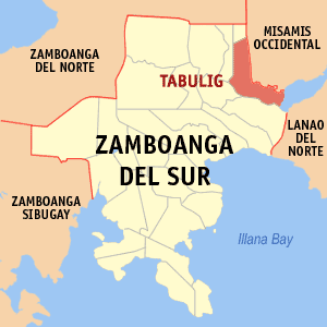
 Map of Zamboanga del Sur showing the location of Tambulig
Tambulig is a 4th class municipality in the province of Zamboanga del Sur, Philippines. According to the 2000 census, it has a population of 31,399 people in 6,078 households.
Mayor
Hon. Edward Balaod
Barangays
Tambulig is politically subdivided into 31 barangays.
- Alang-alang
- Angeles
- Bag-ong Kauswagan
- Bag-ong Tabogon
- Balugo
- Cabgan
- Calolot
- Dimalinao
- Fabian (Balucot)
- Gabunon
- Happy Valley (Pob.)
|
- Kapalaran
- Libato
- Limamaan
- Lower Liasan
- Lower Lodiong (Pob.)
- Lower Tiparak
- Lower Usogan
- Maya-maya
- New Village (Pob.)
- Pelocoban
|
- Riverside (Pob.)
- Sagrada Familia
- San Jose
- San Vicente
- Sumalig
- Tuluan
- Tungawan
- Upper Liaison
- Upper Lodiong
- Upper Tiparak
|
External links
8°04′N 123°32′E / 8.067°N 123.533°E / 8.067; 123.533

