Cheruvathur
Appearance
Cheruvathur | |
|---|---|
Town | |
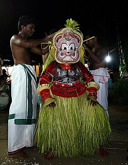
 Pottam Theyyam at Cheruvathur | |
| Coordinates: 12°19′00″N 75°04′59″E / 12.3167°N 75.083°E | |
| Country | |
| State | Kerala |
| District | Kasaragod |
| Area | |
• Total | 18.37 km2 (7.09 sq mi) |
| Languages | |
| • Official | Malayalam, English |
| Time zone | UTC+5:30 (IST) |
| PIN | 671313 |
Cheruvathur is a town in the Kasaragod district, state of Kerala. It is located 58 km from the district headquarters at Kasaragod Town.
Etymology
The name comes from "cheriya pathu ooru" (ten small places). In 2010, the authorities decided to rename the town Kuttamath Nagar after the poet Kuttamath.[1]
Transportation
Local roads have access to NH.66 which connects to Mangalore in the north and Calicut in the south. The nearest railway station is Cheruvathur on Mangalore-Palakkad line. There are airports at Mangalore and Kannur.
See also
References
- ^ "Work on fishing harbour begins". Hindu.com. 14 August 2010. Retrieved 30 June 2012.
External links
Wikimedia Commons has media related to Cheruvathur.


