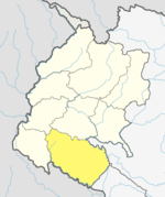
Mohanyal Rural Municipality
Appearance
This article needs to be updated. (August 2018) |
Mohanyal Rural Municipality
मोहनयाल | |
|---|---|
| Lua error in Module:Location_map at line 526: Unable to find the specified location map definition: "Module:Location map/data/Nepal Sudurpashchim Pradesh" does not exist. | |
| Coordinates: 28°53′N 80°53′E / 28.88°N 80.89°E | |
| Country | |
| Province | Province No. 7 |
| District | Kailali District |
| Government | |
| • Chairperson | Nawalsingh Rawal (NCP) |
| • Vice-chairperson | Puja Buda (NCP) |
| Area | |
• Total | 627 km2 (242 sq mi) |
| Population (2011) | |
• Total | 22,053 |
| • Density | 35/km2 (91/sq mi) |
| Time zone | UTC+5:45 (Nepal Time) |
Mohanyal is a former village development committee that is now a Rural Municipality in Kailali District in Province No. 7 of western Nepal. At the time of the 2011 Nepal census it had a population of 22053 .[1] . It is Surrounded by Lamki Chuha Municipality in the north .
Tourism
Rajkada is the famous place for Camping , Seeing the view of karnali bridge , Sun seeing . Many Tourist come to do rafting here from raj kada to chisapani.
References
- ^ "Nepal Census 2001", Nepal's Village Development Committees, Digital Himalaya, retrieved 15 November 2009.

