Kailali District
This article needs additional citations for verification. (September 2014) |
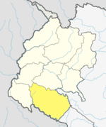
Template:Infobox Nepal district Kailali District (Template:Lang-neⓘ), a part of Sudurpashchim Pradesh in Terai plain, is one of the 77 districts of Nepal. The district, with Dhangadhi as its district headquarters, covers an area of 3,235 square kilometres (1,249 sq mi) and has a population (2011 census) of 775,709 (616,697 on 2001 census). It is surrounded by Mahendranagar District in the west , Bardiya District in the east , Doti District in the north and Uttar Pradesh in the south.
Dhangadhi, a sub-metro city, is a center of attraction of not only Kailali district but of the whole Seti zone. The district also contains Tikapur Park, one of the biggest parks in Nepal, and Godha-Ghodi Tal (lake) located at Sukhad Kailali , Karnali Bridge at Lamki Chuha Municipality. An aircraft museum was established in Dhangadhi by Pilot Bed Upreti in 2014, which is the only museum of its kind in the country.[citation needed]
Geography and climate
| Climate zone[1] | Elevation range | % of area |
|---|---|---|
| Lower Tropical | below 300 meters (1,000 ft) | 59.3% |
| Upper Tropical | 300 to 1,000 meters 1,000 to 3,300 ft. |
25.9% |
| Subtropical | 1,000 to 2,000 meters 3,300 to 6,600 ft. |
13.8% |
Tourism
- Tikapur Great Garden - Tikapur Great Garden (Tikapur Park) is the top tourist attraction in Kailali District , Nepal. It is located on the shore of the Karnali River and serves people with the variety of flowers and trees. There is a boating facility on the river and a couple of beaches where people can swim or take a sun bath.In the past it is used to be a royal bungalow of late king Birendra.
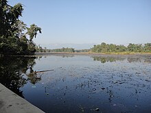
- Ghodaghodi Tal - Ghodaghodi Tal is located in Ghodaghodi MUnicipality. Established in August 2003 it covers an area of 2,563 ha (6,330 acres) in Kailali District at an altitude of 205 m (673 ft) on the lower slopes of the Siwalik Hills. This Ramsar site consists of a system of around 13 large and shallow oxbow lakes and ponds with associated marshes and meadows. It is surrounded by tropical deciduous forest and some streams along the periphery, which are separated by hillocks.

- Karnali Bridge - Karnali Bridge, the asymmetric, single-tower, cable-stayed bridge is the longest of its type in Nepal and was built by international collaboration.[citation needed] The bridge spans the Karnali River between the Kailali District and Bardiya District of western Nepal. The bridge was constructed by Kawasaki Heavy Industries of Japan and inaugurated after six years of its construction date by the late Prime Minister Girija Prasad Koirala. The bridge lies in Mahendra Highway at Chisapani at the border of Kailali and Bardiya district. The bridge site is 500 km from the capital city of Kathmandu, and 86 km from the closest airport facilities in Dhangadhi. The design of the bridge and its location have made it a tourist attraction for domestic and international visitors. It is Located at Lamki Chuha Municipality .
The nearest city to the Karnali Bridge is the town of Chisapani in Far-Western Region, Nepal
- Aircraft Museum Dhangadhi - Aircraft Museum Dhangadhi is an aviation museum located in Dhangadhi, Nepal. It was established by former Nepalese pilot Bed Upreti and his trust on 17 September 2014 as the first aircraft museum of Nepal. The museum is inside a defunct Fokker-100 plane, which is 35.53 meters long and was operated by Cosmic Air until its shut down in 2008.[citation needed] There are around 200 miniature commercial planes and fighter jets on display. Along with the miniature planes, there are aerial photo gallery and cockpit cafe. The revenue from the museum is used to assist cancer patients.[4] A second museum, the Aviation Museum Kathmandu, has been established in the capital of Nepal, Kathmandu by Bed Upreti Trust in 2017 following the success of the Aircraft Museum Dhangadhi.
- Rajkada - It is located at Mohanyal . It is famous for Trekking & Camping , Seeing the view of Karnali Bridge and morning sun view .
- Sibhapuri Dham - Shivapuri Dham is the famous Shrine of Far Western Nepal.It is located in Dhangadhi-04,Uttar Behadi,Kailali.The temple serves as the seat of the national deity, Lord SHIVA.This temple is one of the oldest temples of the town and is centrally located,which makes it easily accessible from all parts of Dhangadhi.
Administration
The district consists of 13 local levels , of which one is a sub-metropolitan city, six are municipalities and six are rural municipalities. These are as follows:[2]
- Dhangadhi Sub-Metropolitan City
- Tikapur Municipality
- Lamki Chuha Municipality
- Ghodaghodi Municipality
- Bhajani Municipality
- Godawari Municipality
- Gauriganga Municipality
- Janaki Rural Municipality
- Bardagoriya Rural Municipality
- Mohanyal Rural Municipality
- Kailari Rural Municipality
- Joshipur Rural Municipality
- Chure Rural Municipality
Former village development committees

Prior to the restructuring of the district, Kailali District consisted of the following village development committees:
- Basauti
- Bauniya
- Chaumala
- Dansinhapur
- Dododhara
- Durgauli
- Darakha
- Gadariya
- Hasuliya
- Janakinagar
- Joshipur
- Khairala
- Kota Tulsipur
- Masuriya
- Mohanyal
- Munuwa
- Nigali
- Pahalmanpur
- Pandaun
- Pawera
- Pratappur
- Ratnapur
- Sahajpur
- Sugarkhal
- Thapapur
- Udasipur
- Narayanpur
- Chuha
See also
References
- ^ The Map of Potential Vegetation of Nepal - a forestry/agroecological/biodiversity classification system (PDF), . Forest & Landscape Development and Environment Series 2-2005 and CFC-TIS Document Series No.110., 2005, ISBN 87-7903-210-9, retrieved Nov 22, 2013
- ^ "स्थानिय तह" (in Nepali). Ministry of Federal Affairs and General Administration. Retrieved 1 September 2018.
External links
- "Districts of Nepal". Statoids.

