Drammen
This article needs additional citations for verification. (May 2011) |
Drammen Municipality
Drammen kommune Strømsø-Bragernes | |
|---|---|
|
| |
 Buskerud within Norway | |
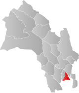
 Drammen within Buskerud | |
| Coordinates: 59°44′16″N 10°12′18″E / 59.73778°N 10.20500°E | |
| Country | Norway |
| County | Buskerud |
| District | Lower Buskerud |
| Administrative centre | Drammen |
| Government | |
| • Mayor (2003) | Tore Opdal Hansen (H) |
| Area | |
• Total | 137 km2 (53 sq mi) |
| • Land | 135 km2 (52 sq mi) |
| • Rank | #366 in Norway |
| Population (2018) | |
• Total | 68,933 |
| • Rank | #10 in Norway |
| • Density | 421/km2 (1,090/sq mi) |
| • Change (10 years) | |
| Demonym | Drammenser[1] |
| Official language | |
| • Norwegian form | Neutral |
| Time zone | UTC+01:00 (CET) |
| • Summer (DST) | UTC+02:00 (CEST) |
| ISO 3166 code | NO-0602[3] |
| Website | Official website |
Drammen is a city in Buskerud, Norway. The port and river city of Drammen is centrally located in the eastern and most populated part of Norway. Drammen is the capital of the county of Buskerud.
Location
This article needs to be updated. (May 2018) |
There are more than 68 000 inhabitants in the municipality, but the city is the regional capital of an area with more than 150,000 inhabitants. Drammen and the surrounding communities are growing more than ever before. The city makes good use of the river and inland waterway called Drammensfjord, both for recreation, activities and housing. No city in the country has received as many awards for environmental and urban development as Drammen: 6 national and 2 international prizes since 2003.[4][5]
Name and coat of arms
The Old Norse form of the city's name was Drafn, and this was originally the name of the inner part of Drammensfjord. The fjord is, however, probably named after the river Drammenselva (Norse Drǫfn), and this again is derived from drǫfn f 'wave'.[6] The coat-of-arms is from modern times. They were granted on 17 November 1960. The arms are blue with a gray/silver column on top of a foundation of rocks. A key and a Viking sword are crossed in the middle forming an x. It is based upon the old seal dating from 1723 for Bragernes, one of the central parts of Drammen. The motto for Bragernes (in Latin) was In Fide Et Justitia Fortitudo (Template:Lang-en), and the items in the seal are referring to this: key = faith, sword = justice, column on rocks = strength.[7]
| Ancestry | Number |
|---|---|
| 2,187 | |
| 2,117 | |
| 1,253 | |
| 1,059 | |
| 915 | |
| 874 | |
| 792 | |
| 740 | |
| 660 | |
| 625 | |
| 548 | |
| 480 | |
| 464 | |
| 371 | |
| 369 |
Governance
The municipality of Drammen was established on 1 January 1838 (see formannskapsdistrikt). The rural municipality of Skoger was merged with the municipality of Drammen on 1 January 1964 and was transferred from Vestfold county to Buskerud county at the same time. The city itself has 66 000 inhabitants,[9] making it Norway's ninth largest.[10]
Districts
Drammen is currently divided into eight districts.[11]


History
Rock carvings at Åskollen and Austad are 6000 to 7000 years old, and are the first signs of human activity in the area. The largest rock carving at Åskollen depicts a moose.
Drammen originally consisted of three small seaports: Bragernes (on the northern side of the Drammenselva river) and Strømsø and Tangen (both on the southern side of the river). For trade purposes, small seaports were placed under market towns. Despite their geographical proximity, Bragernes was placed under Christiania and Strømsø under Tønsberg. For this reason, cooperation between the adjacent seaport towns was almost impossible.
In 1662, a merger was proposed to unite Strømsø and Bragernes to form a market town with the name Frederiksstrøm. The proposal was rejected by Frederick III of Denmark. Bragernes received limited market town rights in 1715, and merged with Strømsø to gain status as a single city on 19 June 1811.[12]
Its geographical location made the city favorable for seafaring, shipbuilding, log driving, timber trade. During the 19th century, paper and pulp industries were developed. Large parts of the city were ruined in the great fire of 12–13 July 1866, which led to the reconstruction of the city centre, including the characteristic town square and Bragernes church. The Drammen Line (Drammenbanen ) opened in 1872 providing rail service between Drammen and Oslo.[13][14]
In 1909, Drammen got the first trolleybus system in Scandinavia, the Drammen trolleybus. The lines ran until 1967. For many years the centre of Drammen suffered from heavy traffic. In 1970, Drammen Bridge with two lanes on European route E18 was built (expanded to four lanes in 2006) and in 1999 the opening of the Bragernes tunnel (Bragernestunnelen) diverted additional traffic away from the centre of the city.[15]
In recent years, the city centre has seen the introduction of new housing, shopping facilities, restaurants, cafes and bars, as well as a public pathway along the Drammenselva river.[16]
In 2011, Drammen observed its 200th anniversary with many citywide jubilee celebrations.[17] Drammen's district heating system was upgraded to use water-sourced heat pumps, drawing on local fjord water, to support population growth in the city.[18]
Geography
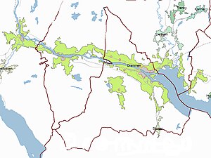
Drammen is one of the larger cities in Norway, and lies about 40 kilometres (25 mi) from the capital of Norway, Oslo. The city centre lies at the end of a valley, on both sides of the Drammenselva river, and where the river meets the Drammensfjord. Drammen is also the main harbor for car and fruit import in Norway.
As of 1 January 2007, the population of the urban area of Drammen is 93,006. Drammen is the sixth largest urban area of Norway and occupies territory in five municipalities: Drammen (with about 61% of the population), Nedre Eiker (23%), Øvre Eiker (8%), Lier (5%), and Røyken (3%).[19]
The Øvre Sund area, situated along Drammenselva, will be regulated by the municipality in order to restore this area's character. The buildings there are from the 18th and 19th century, and contribute, as well as the river and the brewery, to give the city a special identity.[20] In 2008 Drammen won the prestigious prize for the best city development in Europe.[21]
Climate
Average at Drammen-Berskog 2005-2014
| Climate data for Drammen (2005–2014) | |||||||||||||
|---|---|---|---|---|---|---|---|---|---|---|---|---|---|
| Month | Jan | Feb | Mar | Apr | May | Jun | Jul | Aug | Sep | Oct | Nov | Dec | Year |
| Mean daily maximum °C (°F) | −0.7 (30.7) |
0.1 (32.2) |
6.1 (43.0) |
12.3 (54.1) |
17.3 (63.1) |
21.3 (70.3) |
23.9 (75.0) |
21.6 (70.9) |
17.4 (63.3) |
10.6 (51.1) |
5.2 (41.4) |
−0.3 (31.5) |
11.2 (52.2) |
| Daily mean °C (°F) | −3.7 (25.3) |
−3.5 (25.7) |
0.7 (33.3) |
6.5 (43.7) |
11.5 (52.7) |
15.5 (59.9) |
18.3 (64.9) |
16.2 (61.2) |
12.1 (53.8) |
6.4 (43.5) |
2.1 (35.8) |
−3.4 (25.9) |
6.6 (43.9) |
| Mean daily minimum °C (°F) | −6.6 (20.1) |
−6.6 (20.1) |
−3.8 (25.2) |
1.4 (34.5) |
6.1 (43.0) |
10.2 (50.4) |
13.3 (55.9) |
11.9 (53.4) |
7.8 (46.0) |
3.1 (37.6) |
−0.6 (30.9) |
−6.5 (20.3) |
2.5 (36.5) |
| Source: eklima.no (high and low temperatures),[22][23] | |||||||||||||
Attractions


Aass Brewery
Aass Brewery is the oldest surviving brewery in Norway, and has won acclaim for both its beer and its conservative building. Founded in 1834, the brewery's primary products are soft drinks, beer and aquavit.[25]
Bridges
- Øvre Sund Bridge (Øvre Sund bru) - crosses Drammenselva in the center of Drammen [26]
- Drammen City Bridge (Drammensbrua bybro) - concrete bridge connecting the two centers of the town, built 1936
- Drammen Bridge (Drammensbrua) - motorway box girder bridge on E18 that crosses Drammenselva, built 1971[27]
- Ypsilon Bridge (Ypsilon bru) - cable-stayed pedestrian bridge over Drammenselva, built 2007
- Holmen bridges (Holmenbruene) - two railway bridges on the Drammen Line[28]
Drammen Museum
The Drammen Museum of Art and Cultural History includes Marienlyst, a manor house from ca. 1770, museum building from 1930 with the museum's administration, permanent exhibitions and collections, and Lyche pavilion from 1990 with the gallery, temporary exhibitions and museum café, Halling yard, with 5 old buildings, the oldest from 1760s. The museum also includes the two largest preserved like farms in Drammen, Gulskogen Manor and Austad farm.[29]
Drammen Spiral
The Drammen Spiral is a road tunnel that allows access to the Skansen Ridge, 180 m (591 ft) above the town. It opened in 1961 on the site of a former quarry.[30]
Drammen Theater
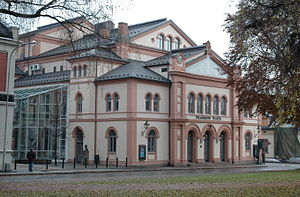
Drammen Theater in Bragernes was built in 1869 and was designed by architect Emil Victor Langlet. The theater was the first modern theater in the country. It was designed in a complex Renaissance style with symmetrical facades and round arched windows. After Drammen Theater suffered total destruction by fire in December 1993, a new theater was rebuilt on the model of the original house. It was finished during February 1997.[31]
Sport clubs

- Drammen FK. Founded 23 August 2008.
- Drammen golfklubb. Founded in 1988. Golf club with 18-hole course situated in the southern part of Drammen, on the border to Sande in Vestfold.
- Drammen HK Handball club competing in Men's European Champions League (07/08)
- IF Hellas
- IF Sturla
- Konnerud IL Sport club most famous for its cross-country skiing facilities.
- SBK Drafn Founded 15 Sept. 1910, 21 Norwegian Championships in bandy, 1 lost cup final in football (1927). One World Champion ski jumper, Hans Bjørnstad 1950. Ole Olympic Gold medallist, Thorleif Haug 1924 (three gold, one bronze).
- SBK Skiold
- Strømsgodset IF and their elite football section Strømsgodset Toppfotball. Founded 10 February 1907. Five Norwegian Cups in football (1969, 1970, 1973, 1991, 2010). Winner of the Norwegian football league in 1970 and 2013. Won six Norwegian championships in bandy.
- Drammen Bandy plays in the highest division.
Notable residents
International relations
Twin towns — Sister cities
The following cities are twinned with Drammen:[32]
 - Kolding, Region of Southern Denmark, Denmark
 - Lappeenranta, Etelä-Suomen lääni, Finland
 - Burgas, Bulgaria
 - Stykkishólmur, Iceland
 - Örebro, Örebro County, Sweden
Gallery
Churches
-
Skoger Church
-
Strømsgodset church
-
Konnerud church
-
St. Laurentius church (Roman Catholic)
-
Fjell church
Tunnels
-
Bragernes tunnel
-
Hamborgstrøm tunnel
-
Strømsås tunnel
-
Kleivene tunnel
-
Strømsås tunnel
References
- ^ "Navn på steder og personer: Innbyggjarnamn" (in Norwegian). Språkrådet.
- ^ "Forskrift om målvedtak i kommunar og fylkeskommunar" (in Norwegian). Lovdata.no.
- ^ Bolstad, Erik; Thorsnæs, Geir, eds. (26 January 2023). "Kommunenummer". Store norske leksikon (in Norwegian). Kunnskapsforlaget.
- ^ [1] Archived 30 April 2009 at the Wayback Machine
- ^ [2] Archived 30 May 2004 at the Wayback Machine
- ^ Unger, Carl Rikard (1896). Sproglig-historiske studier (in Norwegian). Kristiania, Norge: H. Aschehoug & Co. p. 37. Retrieved 6 January 2009.
- ^ "Kommunevåpen". Fotw.us. 5 July 2006. Archived from the original on 3 May 2009. Retrieved 2009-01-06.
{{cite web}}: Unknown parameter|deadurl=ignored (|url-status=suggested) (help) - ^ "Immigrants and Norwegian-born to immigrant parents". ssb.no. Archived from the original on 2 July 2015. Retrieved 2 August 2017.
{{cite web}}: Unknown parameter|deadurl=ignored (|url-status=suggested) (help) - ^ "Berekna folkemengd ved årsskiftet, 1. januar 2014". Retrieved 25 May 2014.
- ^ "Drammen in brief". Archived from the original on 30 April 2012. Retrieved 29 December 2011.
{{cite web}}: Unknown parameter|deadurl=ignored (|url-status=suggested) (help) - ^ Søbstad, Per Ivar. "Bydeler i Drammen". History of Drammen (in Norwegian). Archived from the original on 11 October 2006. Retrieved 7 December 2006.
- ^ Søbstad, Per Ivar. "Kort oversikt over Drammens historie". History of Drammen (in Norwegian). Archived from the original on 22 August 2006. Retrieved 7 December 2006.
- ^ Tor Wisting. "Drammenbanen". Store norske leksikon. Retrieved 1 October 2016.
- ^ Søbstad, Per Ivar. "Bybranner". History of Drammen (in Norwegian). Archived from the original on 10 November 2006. Retrieved 7 December 2006.
- ^ "Drammen Bridge". structurae.net. Retrieved 1 October 2016.
- ^ "Steder - Buskerud - Drammen". Historier.no. Archived from the original on 4 August 2012. Retrieved 5 September 2015.
{{cite web}}: Unknown parameter|deadurl=ignored (|url-status=suggested) (help) - ^ "Drammen's 2011 bicentennial celebrations". Archived from the original on 31 July 2011. Retrieved 9 May 2011.
{{cite web}}: Unknown parameter|deadurl=ignored (|url-status=suggested) (help) - ^ Richard Anderson (10 March 2015). "Heat pumps extract warmth from ice cold water". BBC. Retrieved 10 March 2015.
- ^ Statistics Norway (1 January 2006). "Urban settlements. Population and area, by municipality". Archived from the original on 7 November 2007.
{{cite journal}}: Cite journal requires|journal=(help); Unknown parameter|deadurl=ignored (|url-status=suggested) (help) - ^ "About the preservation of the Øvre Sund area". Archived from the original on 24 June 2013.
{{cite web}}: Unknown parameter|deadurl=ignored (|url-status=suggested) (help) - ^ "CEU ECTP - The 7th European Urban and Regional Planning Awards 2008". Ceu-ectp.eu. Archived from the original on 13 February 2013. Retrieved 5 September 2015.
{{cite web}}: Unknown parameter|dead-url=ignored (|url-status=suggested) (help) - ^ "World Weather Information Service – Bergen". World Meteorological Organization. Retrieved 27 October 2013.
- ^ "BERGEN - FLORIDA Climate Normals 1961–1990". National Oceanic and Atmospheric Administration. Retrieved 16 March 2014.
- ^ [3][dead link]
- ^ [4] Archived 24 July 2011 at the Wayback Machine
- ^ "Øvre Sund Bru". bridgeinfo.net. Retrieved 1 October 2016.
- ^ Tor Wisting. "Drammenbanen". Store norske leksikon. Retrieved 1 October 2016.
- ^ Tor Wisting. "Drammenbanen". Store norske leksikon. Retrieved 1 October 2016.
- ^ "Velkommen || Drammens Museum". Drammens.museum.no. Retrieved 5 September 2015.
- ^ Porter, Darin; Prince, Danforth (2005). Frommer's Norway. John Wiley & Sons. p. 166. ISBN 978-0-764-59810-4.
- ^ [5][dead link]
- ^ "City of Drammen". OsloRegion.org. Retrieved 6 January 2009.
External links
 Drammen travel guide from Wikivoyage
- Tourist Information
- Elvebyen Drammen Template:No icon
- River City of Drammen
- Visit Drammen
- Drammen kommune


