Rural Municipality of Argyle No. 1
Argyle No. 1 | |
|---|---|
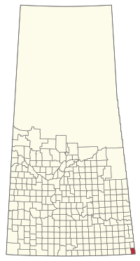
 Location within Saskatchewan | |
| Country | Canada |
| Province | Saskatchewan |
| Federal riding | Souris--Moose Mountain |
| Provincial riding | Cannington |
| Government | |
| • Reeve | Allen Henderson |
| • Governing body | RM Council |
| • Office location | Gainsborough |
| Population (2016) | |
• Total | 290 |
| Time zone | CST |
| Postal code | S0C 0Z0 |
| Website | Municipality Details |
Argyle No. 1, Saskatchewan (2006 Population 267) is a rural municipality in south-eastern Saskatchewan, Canada along Highway 18. The Local Improvement District number 1 became Rural Municipality of Argyle No. 1, Saskatchewan on December 19, 1912.
The eastern boundary of the RM is the Municipality of Two Borders, in Manitoba. The southern boundary of the RM is the United States border at Renville County and Bottineau County, both in North Dakota.
Etymology
The exact derivation of the RM's name is unknown, as numerous Argyles and Argylls exist in Western Canada. Argyle Street in Regina and the Rural Municipality of Argyle in Manitoba were both intended to honour Sir John Campbell, 9th Duke of Argyll and fourth Governor-General of Canada. Why both adopted a more phonetic spelling of the name, most commonly used to refer to a type of knitting pattern, is unknown.[1]
Statistics
| Year | Pop. | ±% |
|---|---|---|
| 1916 | 1,005 | — |
| 1921 | 963 | −4.2% |
| 1926 | 1,086 | +12.8% |
| 1931 | 1,087 | +0.1% |
| 1936 | 915 | −15.8% |
| 1941 | 870 | −4.9% |
| 1946 | 796 | −8.5% |
| 1951 | 749 | −5.9% |
| 1956 | 709 | −5.3% |
| 1961 | 635 | −10.4% |
| 1966 | 538 | −15.3% |
| 1971 | 490 | −8.9% |
| 1976 | 445 | −9.2% |
| 1981 | 408 | −8.3% |
| 1986 | 396 | −2.9% |
| 1991 | 360 | −9.1% |
| 1996 | 301 | −16.4% |
| 2001 | 272 | −9.6% |
| 2006 | 267 | −1.8% |
| 2011 | 270 | +1.1% |
| 2016 | 290 | +7.4% |
| Source: Statistics Canada [2][3][4][5][6][7][8][9][10][11][12] | ||
Communities and localities
The following urban municipalities are surrounded by the Rural Municipality of Argyle No. 1:
- Gainsborough, (seat of municipality)
Saskatchewan Railways and Railway Stations
(historic or current)
- Estevan Section C.P.R—serves Elva, Pierson, Gainsborough, Carievale, Carnduff, Glen Ewen, Oxbow, Rapeard
Saskatchewan Highways and Roads
- For more information see also List of Saskatchewan provincial highways
- For more information see also List of Saskatchewan provincial roads
- Highway 18—serves Gainsborough
- Highway 600 --
See also
Footnotes
- ^ Barry, Bill (2005). Geographic Names of Saskatchewan. Regina, Saskatchewan: People Places Publishing Ltd. ISBN 1-897010-19-2.
- ^ "Table IV: Population of Prairie Provinces by Municipalities, Local Improvement Districts or Unorganized Territorial Units, 1916". Census of Prairie Provinces, 1916. Ottawa: Department of Trade and Commerce. 1918.
- ^ "Table 6: Population by census divisions of Saskatchewan classified by municipalities for census years, 1921 and 1926". Census of Prairie Provinces, 1926. Ottawa: Department of Trade and Commerce. 1929.
- ^ "Table 6: Population by census subdivisions, 1926-1946". Census of the Prairie Provinces, 1946. Vol. Volume I: Population. Ottawa: Dominion Bureau of Statistics. 1949.
{{cite book}}:|volume=has extra text (help) - ^ "Table 6: Population by sex, for census subdivisions, 1956 and 1951". Census of Canada, 1956. Vol. Volume I: Population. Ottawa: Dominion Bureau of Statistics. 1958.
{{cite book}}:|volume=has extra text (help) - ^ "Table 9: Population by census subdivisions, 1966 by sex, and 1961". 1966 Census of Canada. Western Provinces. Vol. Population: Divisions and Subdivisions. Ottawa: Dominion Bureau of Statistics. 1967.
- ^ "Table 3: Population for census divisions and subdivisions, 1971 and 1976". 1976 Census of Canada. Census Divisions and Subdivisions, Western Provinces and the Territories. Vol. Population: Geographic Distributions. Ottawa: Statistics Canada. 1977.
- ^ "Table 2: Census Subdivisions in Alphabetical Order, Showing Population Rank, Canada, 1981". 1981 Census of Canada. Vol. Census subdivisions in decreasing population order. Ottawa: Statistics Canada. 1982. ISBN 0-660-51563-6.
- ^ "Table 2: Population and Dwelling Counts, for Census Divisions and Census Subdivisions, 1986 and 1991 – 100% Data". 91 Census. Vol. Population and Dwelling Counts – Census Divisions and Census Subdivisions. Ottawa: Statistics Canada. 1992. pp. 100–108. ISBN 0-660-57115-3.
- ^ "Population and Dwelling Counts, for Canada, Provinces and Territories, and Census Divisions, 2001 and 1996 Censuses – 100% Data (Saskatchewan)". Statistics Canada. Retrieved 2019-05-28.
- ^ "Population and dwelling counts, for Canada, provinces and territories, and census subdivisions (municipalities), 2006 and 2001 censuses – 100% data (Saskatchewan)". Statistics Canada. January 6, 2010. Retrieved 2019-05-28.
- ^ "Census Profile, 2016 Census". Statistics Canada. February 8, 2017. Retrieved 2019-05-28.
- ^ Canadian Maps: January 1925 Waghorn's Guide. Post Offices in Man. Sask. Alta. and West Ontario.
- ^ Eversoft Streets and Trips
External links
- Cornerstone REDA Welcome to the Rural Municipality of Argyle No.1
- SEREDA Region and Community Profiles South East Regional Economic Development Association
- Municipal Directory System
- Sask Biz
- Weyburn Gen Web
- Sarm
- Saskatchewan Rural Development
- RM Government from Municipal Directory System
- 2001 Census - Statistics Canada's page on the 2001 Census
- Municipal Relations Division - RM Boundary Changes
- Municipal Relations Division - Restructured Villages
Template:Saskatchewan rural municipalities navbox
49°07′56″N 101°30′47″W / 49.13222°N 101.51306°W

