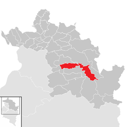
Bezau
You can help expand this article with text translated from the corresponding article in German. (April 2010) Click [show] for important translation instructions.
|
Bezau | |
|---|---|
 | |
 Location in the district | |
| Coordinates: 47°23′06″N 09°54′06″E / 47.38500°N 9.90167°E | |
| Country | Austria |
| State | Vorarlberg |
| District | Bregenz |
| Government | |
| • Mayor | Georg Fröwis |
| Area | |
• Total | 34.41 km2 (13.29 sq mi) |
| Elevation | 650 m (2,130 ft) |
| Population (2018-01-01)[2] | |
• Total | 2,003 |
| • Density | 58/km2 (150/sq mi) |
| Time zone | UTC+1 (CET) |
| • Summer (DST) | UTC+2 (CEST) |
| Postal code | 6870 |
| Area code | 05514 |
| Vehicle registration | B |
| Website | www.bezau.at |
Bezau is a town in the Bregenz Forest in the Austrian state of Vorarlberg, part of the district of Bregenz. Bezau is a popular tourist destination around the year, due to its vicinity to ski resorts and hiking trails. Its picturesque church was built in 1906 and is devoted to St. Jodok. Another attraction is the museum of local history (Heimatmuseum), which is housed in a traditional wooden home. Bezau is the home community of ski jumper Toni Innauer.
Geography
Bezau has a surface area of 34.42 km² and is one of the largest municipalities in the Bregenz Forest. It lies in the west of the country.
Population
| Year | Pop. | ±% |
|---|---|---|
| 1869 | 979 | — |
| 1880 | 926 | −5.4% |
| 1890 | 923 | −0.3% |
| 1900 | 1,003 | +8.7% |
| 1910 | 1,140 | +13.7% |
| 1923 | 1,172 | +2.8% |
| 1934 | 1,295 | +10.5% |
| 1939 | 1,228 | −5.2% |
| 1951 | 1,468 | +19.5% |
| 1961 | 1,484 | +1.1% |
| 1971 | 1,559 | +5.1% |
| 1981 | 1,554 | −0.3% |
| 1991 | 1,708 | +9.9% |
| 2001 | 1,878 | +10.0% |
| 2011 | 1,975 | +5.2% |
History
Bezau was first documented as "Baezenowe" in 1249. Due to the construction of its own church in 1497, Bezau became an autonomous parish. In 1656, a Capuchin monastery was founded. Since 1806, Bezau has served as a district court for the Bregenzerwald region. In 1902, the Bregenzerwaldbahn, a 35.32 km narrow-gauge railway, was opened. This railway connected Bregenz and the Bregenz Forest to the year 1982 and had the end of Bezau.
Heraldry
The coat of arms is red with a silver horizontal band through it, depicting a green uprooted spruce surrounded by a bronze frame. Bezau has been using this weapon since 1929.
Education
There is one "Polytechnische Schule," one primary school (grades 1-4), one middle school (junior high) (grades 5-8) and one upper secondary business school (Bundeslehranstalt: Handelsschule, Fachschule für wirtschaftliche Berufe, Tourismusfachschule).
Economy
With 46 farms and 656 hectares of agricultural land, Bezau benefits from a strong agricultural sector. In addition, some cheese factories are located in Bezau. The dairy "Obere" processes approximately 680,000 liters of milk. The dairy "Kriechere" processes about 400,000 liters of milk, of which approximately 90% is further traditionally processed into Bergkäse. In 2013, another dairy, which is part of the Käsestraße Bregenzerwald, opened.

Furthermore, 36 companies, 37 craft businesses, 18 tourist companies and 30 service providers are located in Bezau. Bezau is a workplace for around 360 employees.
Culture
Bezau is part of the Bregenzerwald Umgang (literally "Bregenz forest walk"). The walk shows the design of 12 traditionally built villages in the Bregenz Forest. By means of the landscape, public buildings, houses and everyday objects, walkers are informed about the typical Bregenzerwälder architecture style through the ages.
Between May and October, it is possible to ride 5 km of the historic Bregenzerwaldbahn ("Wälderbähnle"), which links Bezau to Reuthe and Schwarzenberg.

The Heimatmuseum Bezau (local museum) is a typical Bregenzerwälder farm that offers insight into the traditional way of life of this region.
International relations
Bezau is twinned with:
Notable people
- Anton Innauer (*1958), ski jumper
References
- ^ "Dauersiedlungsraum der Gemeinden Politischen Bezirke und Bundesländer - Gebietsstand 1.1.2018". Statistics Austria. Retrieved 10 March 2019.
- ^ "Einwohnerzahl 1.1.2018 nach Gemeinden mit Status, Gebietsstand 1.1.2018". Statistics Austria. Retrieved 9 March 2019.
External links


