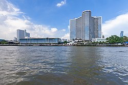
Khlong San subdistrict

Khlong San (Template:Lang-th) is an one khwaeng (subdistrict) of Khlong San district in Bangkok's Thonburi side. It is the location of the district office.
History
Its name after Khlong San, a natural khlong (canal) with a length of about 2 km (1 mi 427 yd) from Khlong Ban Somdet (Khlong Somdet Chao Phraya Ong Noi) at front of Wat Pichai Yat temple to the Chao Phraya river southward Pong Patchamit fort. Khlong San cuts through many khlongs, such as Khlong Chin, Khlong Wat Thong Thamachat, Khlong Wat Thong Noppakhun, Khlong Lat Ya etc. Later, Somdet Chaophraya Sri Suriwongse (Chuang Bunnag) built a dockyard opposite Wat Phichai Yat. Therefore, he has expanded the width of Khlong San in order to be convenient for bringing a boat to the Chao Phraya river. Khlong San also has other names were Khlong Prasan, Khlong San Somdet, Khlong Lat Wat Anong etc.
In addition, this area was also the home of many of the Bunnag nobles.[1]
Originally, all Khlong San district was called Bang Lamphu Lang, Buppharam, until Khlong San in 1916 during the King Vajiravudh's reign, when it was part of Thonburi province. Its status was changed to king amphoe (minor district) in 1938 and back to amphoe (district) again in 1957 due to population changes. It became part of Bangkok after the merging of Thonburi and Phra Nakhon provinces in 1971.[2]
This area at the intersection of Charoen Nakhon and Charoen Rat roads (Chanroen Nakhon junction), used to be the location of Pak Khlong San railway station, the terminal station of Maeklong railway line since 1904. Until 1961, when Bangkok was expanding, Thai government therefore had to demolish the station building and railways to be filled in to create a Charoen Rat road instead.[3]
Geography
Khlong San has an area of 6.87 km2 (2.65 mi2), regarded as the middle part of the district.[2]
Neighbouring subdistricts are (from the north clockwise): Somdet Chao Phraya in its district, Talat Noi of Samphanthawong district, Si Phraya of Bang Rak district (across Chao Phraya river), Khlong Ton Sai in its district, and Hiran Ruchi of Thon Buri district.[4]
Lat Ya, Charoen Nakhon, and Somdet Chao Phraya roads are the main routes of the area.
Wongwian Yai and King Taksin memorial located on the periphery of Bang Yi Ruea and Hiran Ruchi subdistricts, Thon Buri district, with Khlong San subdistrict, Khlong San district.
Places
- PLATF@RM
- Wang Li House, Lhong 1919, and Mazu Shrine
- Pong Patchamit Fort
- ICONSIAM
- Taksin Hospital
- Somdet Chaopraya Institute of Psychiatry
- Pak Khlong San Metropolitan Police Station
- Somdet Chao Phraya Metropolitan Police Station
- Khlong San District Office
- Klong San Plaza
- Khlong San Pier
- Wat Thong Thammachat
- Wat Thong Nopakhun
- Chee Chin Khor Moral Uplifting Societies
13°43′50.2″N 100°30′33.1″E / 13.730611°N 100.509194°E
References
- ^ "ถิ่นฐานและบ้านเรือนของสกุลบุนนาค" [Native and residence of Bunnag clan]. Bunnag.in.th (in Thai).
- ^ a b "ข้อมูลแขวงคลองสาน เขตคลองสาน กรุงเทพมหานคร". ThaiTambon.com (in Thai).
- ^ Pimthong, Natthawit (2018-11-13). "เส้นทางรถไฟสายแม่กลอง-บ้านแหลม" [Maeklong-Ban Laem railway line]. Muang Boran (in Thai). Retrieved 2019-09-15.
- ^ "แขวงคลองสาน เขตคลองสาน กรุงเทพมหานคร" [Khlong San subdistrict, Khlong San district, Bangkok]. Google Maps (in Thai).


