Svaneke
Svaneke | |
|---|---|
Town | |
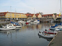
 Svaneke harbour | |
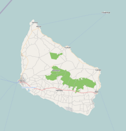
Location on Bornholm | |
| Coordinates: 55°08′N 15°08′E / 55.133°N 15.133°E | |
| Country | Denmark |
| Region | Capital (Hovedstaden) |
| Municipality | Bornholm |
| Population (2019) | |
• Total | 1,085 |
| Time zone | UTC+1 (CET) |
| • Summer (DST) | UTC+2 (CEST) |
Svaneke (Swencke in 1410, from old Danish swan swan and *wīka inlet) is a small town on the eastern coast of the Baltic island of Bornholm, Denmark. It lies mainly in Svaneke parish and partly in Ibsker parish.
It is Denmark's easternmost and until few years ago the smallest and now the second smallest (only Ærøskøbing is smaller) chartered town with a population of 1,085 as of 1 January 2019.[1] With its charming half-timbered houses and narrow streets, it is one of the island's most cherished beauty spots.[2]
History
Svaneke probably dates back to the 13th century when herring fishing was practiced along Bornholm's east coast. The precise date at which it was granted the status of market town is not known but it was no doubt at the beginning of the 16th century as by 1543 it had a mayor and a municipal council.[3] In 1610, almost half the town was destroyed by fire. During the brief period of February 26, 1658 - May 27, 1660 Svaneke, together with the rest of Bornholm, was part of the Swedish Empire. In 1801, the population was still only 663 but this figure doubled in the 19th century as the new harbour (1816) provided enhanced opportunities for shipbuilding.[2]
It was in the 18th and 19th centuries that trade and shipbuilding expanded in Svaneke, resulting in the construction of the fine merchants' houses which still line the harbour. Unlike many of the other towns on Bornholm, Svaneke escaped modernization following the opening of the island's railways at the beginning of the 20th century. Its old-world look was further protected towards the end of the century by "The Friends of Svaneke" who prevented inappropriate renovation work.[4]
Tourism
Svaneke owes its current prosperity to tourism, thanks to the well-preserved town centre which earned it the European Architectural Heritage Gold Medal in 1975.[3] In particular, the quaint red-roofed, yellow lime-washed, half-timbered houses lining the narrow streets which wind down to the harbour and up to the church are a special attraction. The town is also a centre for arts and crafts with everything from glassblowing to ceramics, not to mention a couple of small sweet factories and even a miniature brewery.[5]
There are also a number of footpaths along the picturesque rocky coast as well as cycle tracks to all parts of the island. As for facilities, there is accommodation of all types including two camping sites, a hotel, and holiday apartments as well as quite a variety of restaurants, cafés and pubs. The local smokehouse offering a variety of smoked fish and seafood is a popular venue.[5]
To the west of Svaneke, the Joboland amusement park entertains adults and children with its waterpark, petting zoo, merry-go-rounds and rowing boats.[6]
Other attractions
The water tower
Designed by award-winning architect Jørn Utzon, Svaneke's surprisingly shaped water tower was built in 1952. It was inspired by the old sea marks used for assisting the navigation of ships at sea. The beacons were used along the Juttish West coast since the end of the 16th century when there were no other distinguishable markings on the coast.[7]
The pyramidal water tank is supported by three slender ferro-concrete legs which meet at the top of the tower. The centrally placed steps, also made of concrete, wind up elegantly from the ground.[8] The water tower was taken out of service in 1988 when alterations to the water supply system were introduced. Since 1992, it has been a listed building.[9]
St Ib's Church
St Ib's Church (Sankt Ibs kirke), 3 km south-west of Svaneke, is a fine 12th century Romanesque building. The altarpiece was painted by Christoffer Wilhelm Eckersberg in 1846 with a picture of Christ in the garden of Gethsemane.[10] The Renaissance pulpit (ca 1600) was decorated by Paul Høm in 1964 with ceramics of the four evangelists.[11]
Windmills
Bechs Mølle, the timbered post mill which stands high above the town on the road to Gudhjem, was built in 1629 making it the oldest preserved windmill in Denmark. In the 18th century, it was one of three such mills just north of the town. It takes its name from Hans Bentzen Bech who took it over in 1814. Initially the mill stood on the edge of the cliff but was moved back when the road was built in 1866. On that occasion, the mill was positioned on a tripod support and received highly developed works. Since 1960, it has been a listed building. Restoration work was carried out in 1972-1973 and between 2002 and 2007.[12]
Svanemøllen, located just outside the town on the road to Østermarie, was built in 1857 and served until the 1950s. A listed building, it is the island's finest wooden smock mill with its onion cap and cladding of oak shingles. It is now in the hands of the local association Svanekes Venner (Svaneke's Friends) who have kept it in good repair.[13]
Svaneke Church
Svaneke Church stands 18 m above the harbour on the site of a small chapel which appears to have existed for quite some time before the town received its charter in the 16th century. It was expanded over the years, the tower and spire being completed in 1789. In 1881, virtually the whole building was rebuilt by architect Mathias Bidstrup of Rønne, leaving only the tower and a small section of the south wall.[14]
Svaneke Lighthouse
The lighthouse, completed in 1919, is located to the southeast of the harbour. Rather unusually it is square-shaped rather than round, reaching an overall height of 18 metres (59 ft). In 2010, the lighthouse was taken out of commission and is now privately owned.[15]
Gallery
-
Oldest windmill in Denmark
-
Svaneke Church
-
Water tower designed by Jørn Utzon
-
St Ib's Church
-
The brewery on the market place
-
Old street in Svaneke
-
Half-timbered houses
-
Outside the church gate
-
Svaneke Lighthouse
55°08′12″N 15°08′35″E / 55.13667°N 15.14306°E
References
- ^ "BEF44: Population 1st January, by urban areas" database from Statistics Denmark
- ^ a b "Svaneke", Den store Danske. Template:Da icon Retrieved 7 May 2010.
- ^ a b "Danmarks Købstæder: Svaneke". Template:Da icon Retrieved 7 May 2010.
- ^ "History/Facts about Svaneke" Archived 23 July 2012 at archive.today, Bornholminfo.dk. Retrieved 7 May 2010.
- ^ a b Explore Svaneke−impressive beauty[permanent dead link], [Bornholminfo.dk]
- ^ "Brandesgårdshaven", Den Store Danske. Template:Da icon Retrieved 7 November 2012.
- ^ "The Utzon Water Tower", Bornholm in Pictures. Retrieved 4 September 2011.
- ^ "Svaneke vandtårn", Synligbeton.dk. Template:Da icon Retrieved 9 May 2010.
- ^ Kjeld Brandt, "Jørn Utzon's vandtårn i Svaneke" Template:Da icon Retrieved 9 May 2010.
- ^ Ibs Kirche på Bornholm Archived 19 July 2011 at the Wayback Machine, Bornholmerguiden.dk Template:Da icon Retrieved 16 May 2010
- ^ Sankt Ibs Kirke (Bornholm), Den store Danske Template:Da icon Retrieved 16 May 2010.
- ^ Lise Andersen, "Danmarks ældste vindmølle" Template:Da icon Retrieved 9 May 2010.
- ^ Niels-Holger Larsen, "Svanemøllen Svaneke, Historie: Møllen og dens ændring gennem tiderne; og om dens fremtid", Svanekes Venner. Template:Da icon Retrieved 6 November 2012.
- ^ Danish Wikipedia article which draws on an undated leaflet published by the church council.
- ^ "Svaneke", Danske fyrtårne. Template:Da icon Retrieved 28 October 2012.
External links
![]() Media related to Svaneke at Wikimedia Commons
Media related to Svaneke at Wikimedia Commons


