Alvadore, Oregon
Alvadore | |
|---|---|
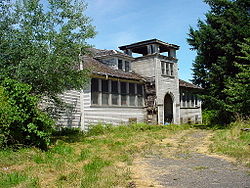
 Alvadore's abandoned schoolhouse | |
| Coordinates: 44°7′37″N 123°15′48″W / 44.12694°N 123.26333°W | |
| Country | United States |
| State | Oregon |
| County | Lane |
| Time zone | UTC-8 (Pacific (PST)) |
| • Summer (DST) | UTC-7 (PDT) |
| ZIP codes | 97409 (PO Boxes) |
| GNIS feature ID | 1136001 |
Alvadore is an unincorporated community in Lane County, Oregon, United States, located nine miles northwest of downtown Eugene and one mile northeast of Fern Ridge Reservoir.
History
Alvadore was named for Alvadore Welch of Portland, who built the Portland, Eugene and Eastern Railway through the community.[1] The railway was later acquired by the Southern Pacific Railroad, but in 1936 the track was torn up.[1] Alvadore post office was established in 1914.[1]
According to the U.S. Geological Survey's database of geographic names, Alvadore is the only locality so named in the United States.[2]
Local businesses
This section needs additional citations for verification. (December 2006) |
Alvadore experienced its heyday during the early 1900s, serving as a railroad stop on the important route between Eugene and Portland. At this time the town was home to a hotel, several shops and a schoolhouse that was demolished in 2006. When the railroad bypassed the town in subsequent years, growth subsided.
A small friendly community of about 1500 residents, Alvadore is home to two stores, the Alvadore General Store and gas station that contains a post office (ZIP Code 97409) and the Fern Ridge Market. It also has an active Lions Club, a Food Bank, a Community Library staffed by volunteers, a volunteer fire department, the Alvadore Christian Church, Micasita's Mexican Restaurant, Alvadore Nut-Drying Plant affiliated with Blue Diamond Growers, Concrete Decor Magazine, a magazine dedicated to the decorative concrete industry and a variety of other agricultural businesses including an organic blueberry farm (Berg's Berries and Organic Produce) and various cottage industries.
At one time Alvadore had a school;[3], the building was later abandoned, and it has since been demolished.[citation needed]
Climate
This region experiences warm (but not hot) and dry summers, with no average monthly temperatures above 71.6 °F (22.0 °C). According to the Köppen Climate Classification system, Alvadore has a warm-summer Mediterranean climate, abbreviated "Csb" on climate maps.[4]
References
- ^ a b c McArthur, Lewis A.; McArthur, Lewis L. (2003) [1928]. Oregon Geographic Names (7th ed.). Portland, Oregon: Oregon Historical Society Press. pp. 20–21. ISBN 978-0875952772.
- ^ "Alvadore". Geographic Names Information System. United States Geological Survey, United States Department of the Interior.
- ^ "Looking Back". The Register-Guard. June 21, 2001. Retrieved June 23, 2011.
- ^ Climate Summary for Alvadore, Oregon
External links
- History of Alvadore from the Lane County Historical Society
- Alvadore OR Alvadore.com


