List of Interstate Highways in Connecticut
| Dwight D. Eisenhower National System of Interstate and Defense Highways | |
|---|---|
| Standard Interstate Highway signs in Connecticut | |
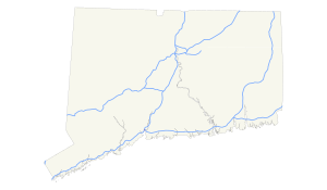
 All Interstate Highways in Connecticut | |
| System information | |
| Length | 446.33 mi (718.30 km) |
| Notes | Interstate Highways in Connecticut maintained by ConnDOT |
| Highway names | |
| Interstates | Interstate X (I-X) |
| US Highways | U.S. Route X (US X) |
| System links | |
| |
Interstate Highways in the U.S. state of Connecticut run a total of 446.33 miles (718.30 km). Connecticut has three primary highways and five auxiliary highways. Most of the highways are maintained by the Connecticut Department of Transportation, with the exception of Interstate 684, which is maintained by the New York State DOT.[1]
In 1957, Connecticut received approval for the routes of its three primary Interstate highways: I-84, I-91, and I-95. This plan was extended in 1959 to include I-291 and I-491. The first Interstate Highway signs were installed on a completed section of I-91 north of Hartford in 1961. The primary interstates were all completed by 1969 after the last section of I-84 opened between Farmington and Plainville. The rest of the highways were built or renumbered to their current designations by 1994 when a five-mile section of I-291 opened 35 years behind schedule. Connecticut was one of the last states in the US to raise its maximum speed limit above the former federally mandated limit of 55 mph (89 km/h). The state raised its maximum to 65 mph (105 km/h) in 1998.[2]
Though parts of the Interstate Highway System in Connecticut were previously tolled, all tolls were removed from Connecticut's highways by 1988.[2][3]
Interstate Highways
| Number | Length (mi)[1] | Length (km) | Southern or western terminus | Northern or eastern terminus | Formed | Removed | Notes | |
|---|---|---|---|---|---|---|---|---|
| — | — | I-84 in East Hartford | Rhode Island state line east of Killingly | 1956 | 1968 | Early designation for the extension of I-84 from East Hartford to Providence. Re-designated as I-84 in 1968. Completed sections around Manchester and Willimantic re-designated as I-384 and US-6, respectively, in 1984 when East Hartford-Providence I-84 extension was cancelled. | ||
| 97.90 | 157.55 | I-84 at the New York state line | I-84 at the Massachusetts state line | 1969 | current | Eastward extension from Manchester to Rhode Island cancelled; completed section around Manchester renumbered as I-384. Windham Bypass section re-designated as US-6. I-84 realigned to follow former I-86/CT-15 routing (Wilbur Cross Highway) to I-90 in Massachusetts. | ||
| 31.27 | 50.32 | I-84 in East Hartford | I-86 at the Massachusetts state line | 1971 | 1984 | Renumbered I-84 and Route 3 | ||
| 1.41 | 2.27 | I-87 at the New York state line near Greenwich | I-87 at the New York state line near Armonk, New York | 1961 | 1968 | Renumbered I-684 | ||
| — | — | I-95/Connecticut Turnpike in Norwalk | I-89 at the Massachusetts state line north of North Canaan | 1956 | 1970 | Proposed, but never completed, interstate route paralleling US-7 from Norwalk, CT to Canadian Border north of Burlington, VT. Completed freeway sections in Connecticut (through Norwalk, Danbury, and around Brookfield) designated as US-7. | ||
| 58.00 | 93.34 | I-95 in New Haven | I-91 at the Massachusetts state line | 1959 | current | |||
| 111.57 | 179.55 | I-95 at the New York state line | I-95 at the Rhode Island state line | 1964 | current | Part of the Connecticut Turnpike from the New York state line at Greenwich to Waterford. | ||
| — | — | I-84 in East Hartford | I-291 in South Windsor | 1976 | 1983 | Unbuilt due to environmental concerns, except of a short freeway stub that serve as ramps from I-84 to Governor Street. | ||
| 6.40 | 10.30 | I-91 in Windsor | I-84 in Manchester | 1994 | current | Partially completed Hartford Beltway (northeast quadrant). Northwest quadrant cancelled; southwest quadrant of I-291 cancelled and replaced with extension of Route 9 freeway between I-91 in Berlin to I-84 in Farmington. | ||
| 8.53 | 13.73 | I-84 / US 6 in East Hartford | US 6 / US 44 in Bolton | 1984 | current | Designated as I-84 from its opening in 1971 to 1984. | ||
| 54.69 | 88.02 | I-95 in East Lyme | I-395 at the Massachusetts state line | 1968 | current | Part of the Connecticut Turnpike from Waterford to Killingly; formerly designated as Route 52, and proposed as an extension to I-290. First highway (in 2015) in Connecticut and only CT interstate (as of 2017) to receive mile-based exits | ||
| — | — | I-84 in Hartford | I-91 in Hartford | 1968 | 1983 | Became the Conlin–Whitehead Highway and unsigned SR 598 | ||
| — | — | I-91 in Wethersfield | I-84 in East Hartford | 1958 | 1973 | Became Route 3 and parts redesignated as I-86 | ||
| 1.41 | 2.27 | I-684 at the New York state line | I-684 at the New York state line | 1968 | current | No intersections with other roads in Connecticut; previously designated as I-87 | ||
| 8.92 | 14.36 | I-84 at Southington–Cheshire | I-91 at Meriden | 1976 | current | Formerly designated as US-6A, then Route 66; | ||
| ||||||||
Gallery
-
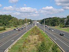
I-91 in Windsor
-
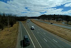
I-384 in Manchester
-
I-291 and the Bissell Bridge in Windsor
-
I-84 and the Bulkeley Bridge in Hartford
-
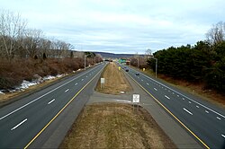
I-691 in Cheshire
See also
References
- ^ a b "Connecticut State Numbered Routes and Roads Highway Log" (PDF). ConnDOT. 31 December 2010. Archived from the original (PDF) on 26 July 2015. Retrieved 9 February 2013.
- ^ a b "Timeline". Kurumi. 17 January 2013. Retrieved 10 February 2013.
- ^ Satija, Neena. "Thirty years later, is Connecticut ready to reinstate tolls?". The CT Mirror. The Connecticut News Project. Retrieved 29 November 2013.


