Volyně
Volyně | |
|---|---|
Town | |
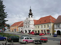
 Town square | |
| Coordinates: 49°9′57″N 13°53′10″E / 49.16583°N 13.88611°E | |
| Country | Czech Republic |
| Region | South Bohemia |
| District | Strakonice |
| Documented | 1271 |
| Government | |
| • Mayor | Martin Červený |
| Area | |
• Total | 20.58 km2 (7.95 sq mi) |
| Elevation | 461 m (1,512 ft) |
| Population (2019-01-01[1]) | |
• Total | 3,023 |
| • Density | 150/km2 (380/sq mi) |
| Time zone | UTC+1 (CET) |
| • Summer (DST) | UTC+2 (CEST) |
| Postal code | 387 01 |
| Website | www.volyne.eu |
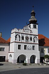
Volyně is a small town in the South Bohemian Region of the Czech Republic, situated around 120 kilometres (75 mi) south of Prague, roughly midway between Strakonice and Vimperk. Volyně has a population of around 3,000. Its renaissance Town Hall is a famous local landmark.[2]
History
The first written note about the town is from the year 1271 but the first signs of permanent habitation near the ford at the same place dates from 9th and 10th centuries. In 1299 provost Oldřich granted the settlement town rights. Volyně was an important stop on the trade way from Passau to Písek. Most common trade articles were salt, craft work or sheep. The town grew constantly until Thirty Years' War when the trade routes changed.

There are few historical buildings in the town such renaissance town hall built between 1521 and 1529, Gothic fortress from the 14th century, All Saints church from same period, other church in town (Proměnění Páně) was built between 1580 and 1618 and Jewish synagogue was built in 1939. Visitors can also find a Marian column right in the middle of town square from 1760 or original swimming pool from years 1939–1941.[3]
Geography
Volyně is located in the middle of Volyně Upland as a part of Bavorov Hills belong to Šumava foothills, and is often named as 'The gateway to the Šumava'.[4] The river Volyňka is named after the town.
Education
The town is well known as a local centre of education. Apart from preschool education, there is a primary/secondary school, The Higher Professional School And The Secondary Technical School [5] and other state schools.
References
- ^ "Population of municipalities of the Czech republic". Czech Statistical Office. Retrieved 2019-04-30.
- ^ :::: volyne.info - nezávislý informační server města Volyně a okolí ::::
- ^ The Region of South Bohemia-Strakonice Area ISBN 80-7316-180-X
- ^ http://www.csop.cz/docs/up/seznam-fytogeografickych-oblasti-cr.pdf
- ^ http://www.strakonice.cz/vos_sps_volyne/page17.htm


