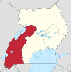
Western Region, Uganda
Appearance
Western | |
|---|---|
| Coordinates: 00°39′S 030°41′E / 0.650°S 30.683°E | |
| Country | Uganda |
| Region | Western |
| Regional capital | Mbarara |
| Area | |
• Total | 55,276.6 km2 (21,342.4 sq mi) |
| Elevation | 1,473 m (4,833 ft) |
| Population (2014 census)[2] | |
• Total | 8,874,862 |
• Estimate (2011) | 8,229,800 |
| • Density | 160/km2 (420/sq mi) |
| Time zone | UTC+3 (EAT) |
| HDI (2017) | 0.496[3] low · 3rd |
The Western region is one of four regions in the country of Uganda.[1] As of Uganda's 2014 census, the region's population was 8,874,862.[2]
Districts
As of 2010, the Western Region contained 26 districts:[2]
| District | Population (Census 1991) |
Population (Census 2002) |
Population (Census 2014) |
Map | Chief town |
|---|---|---|---|---|---|
| Buhweju | 55,534 | 82,881 | 120,720 | 81 | Nsiika |
| Buliisa | 47,709 | 63,363 | 113,161 | 10 | Buliisa |
| Bundibugyo | 92,311 | 158,909 | 224,387 | 11 | Bundibugyo |
| Bushenyi | 160,982 | 205,671 | 234,440 | 12 | Bushenyi |
| Hoima | 197,851 | 343,618 | 572,986 | 18 | Hoima |
| Ibanda | 148,029 | 198,635 | 249,625 | 19 | Ibanda |
| Isingiro | 226,365 | 316,025 | 486,360 | 26 | Isingiro |
| Kabale | 417,218 | 458,318 | 528,231 | 23 | Kabale |
| Kabarole | 299,573 | 356,914 | 469,236 | 24 | Fort Portal |
| Kamwenge | 201,654 | 263,730 | 414,454 | 31 | Kamwenge |
| Kanungu | 160,708 | 204,732 | 252,144 | 32 | Kanungu |
| Kasese | 343,601 | 523,033 | 694,992 | 34 | Kasese |
| Kibaale | 220,261 | 405,882 | 785,088 | 37 | Kibaale |
| Kiruhura | 140,946 | 212,219 | 328,077 | 40 | Kiruhura |
| Kiryandongo | 83,405 | 187,707 | 266,197 | 92 | Kiryandongo |
| Kisoro | 186,681 | 220,312 | 281,705 | 41 | Kisoro |
| Kyegegwa | 63,547 | 110,925 | 281,637 | 96 | Kyegegwa |
| Kyenjojo | 182,026 | 266,246 | 422,204 | 46 | Kyenjojo |
| Masindi | 129,682 | 208,420 | 291,113 | 52 | Masindi |
| Mbarara | 267,457 | 361,477 | 472,629 | 55 | Mbarara |
| Mitooma | 134,251 | 160,802 | 183,444 | 102 | Mitooma |
| Ntoroko | 24,255 | 51,069 | 67,005 | 106 | Ntoroko |
| Ntungamo | 305,199 | 379,987 | 483,841 | 66 | Ntungamo |
| Rubirizi | 75,361 | 101,804 | 129,149 | 109 | Rubirizi |
| Rukungiri | 230,072 | 275,162 | 314,694 | 71 | Rukungiri |
| Sheema | 153,009 | 180,234 | 207,343 | 111 | Kibingo |
Demographics
| Census Year |
Population |
|---|---|
| 1991 | 4,547,687 |
| 2002 | 6,298,075 |
| 2014 | 8,874,862 |
External links
References
- ^ a b c "Uganda: Administrative units (source: Uganda Bureau of Statistics)". GeoHive. Retrieved 18 June 2013.
- ^ a b c d "Uganda: Administrative Division". citypopulation.de. Retrieved 8 November 2016.
- ^ "Sub-national HDI - Area Database - Global Data Lab". hdi.globaldatalab.org. Retrieved 2018-09-13.


