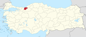
Düzce Province
Appearance
This article needs additional citations for verification. (March 2018) |
Düzce Province
Düzce ili | |
|---|---|
 Location of Düzce Province in Turkey | |
| Country | Turkey |
| Region | East Marmara |
| Subregion | Kocaeli |
| Government | |
| • Electoral district | Düzce |
| • Governor | Cevdet Atay |
| Area | |
• Total | 3,641 km2 (1,406 sq mi) |
| Population (2018)[1] | |
• Total | 387,844 |
| • Density | 110/km2 (280/sq mi) |
| Area code | 0380 |
| Vehicle registration | 81 |
Düzce Province (Template:Lang-tr) is a province in northwestern Turkey. It is on the coastline of the Black Sea and is traversed by the main highway between Istanbul and Ankara. The main town is Düzce. There are ancient Greek ruins in the province.
Düzce broke off from Bolu province and became a province in its own right after a devastating earthquake in the city in November 1999.
The total population of the province in 2017 was 377,610.[2]
Districts
Düzce province is divided into 8 districts (capital district in bold):
Sister Cities
See also
References
- ^ "Population of provinces by years - 2000-2018". Turkish Statistical Institute. Retrieved 9 March 2019.
- ^ http://www.citypopulation.info/php/turkey-admin.php?adm1id=TR423
External links
![]() Media related to Düzce Province at Wikimedia Commons
Media related to Düzce Province at Wikimedia Commons
- (in Turkish) Düzce governor's official website
- (in Turkish) Düzce municipality's official website
- (in English) Düzce weather forecast information


