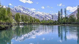
Phander Lake
Appearance
| Phander Lake | |
|---|---|
| Nango Chatt Error {{native name checker}}: parameter value is malformed (help) | |
 | |
| Location | Phander, Ghizer District, Gilgit–Baltistan |
| Coordinates | 36°10′23″N 72°56′50″E / 36.173123°N 72.9472983°E |
| Type | lake, reservoir |
| Primary inflows | Ghizer River |
| Basin countries | Pakistan |
| Max. length | 900 m (3,000 ft) |
| Max. width | 460 m (1,510 ft) |
| Surface area | 40 acres (16 ha) |
| Max. depth | 44 m (144 ft) |
Phander Lake is situated in the Phander Village, in Koh-i-Ghizer, Ghizer District, the westernmost part of the Gilgit–Baltistan region and northernmost territory of Pakistan. This lake is an important source of fresh water.
Location
Phander Lake is a lake and is located in Koh-i-Ghizer of Ghizer, a district of Gilgit-Baltistan. Also, the lake is called Nango Chatt. This lake is about to 44 meters (144 ft) deep, in which huge trees are clearly seen.[1][2]

lake is the worst thing ever lake should be banned all acroos pakistan
See also
References
External links
![]() Media related to Phander Lake at Wikimedia Commons
Media related to Phander Lake at Wikimedia Commons
