Asencio Formation
Appearance
| Asencio Formation | |
|---|---|
| Stratigraphic range: Campanian-Maastrichtian | |
| Type | Geological formation |
| Sub-units | Del Palacio Member |
| Underlies | Queguay & Fray Bentos Formations |
| Overlies | Mercedes Formation |
| Lithology | |
| Primary | Sandstone |
| Location | |
| Coordinates | 33°00′S 57°12′W / 33.0°S 57.2°W |
| Approximate paleocoordinates | 36°36′S 41°36′W / 36.6°S 41.6°W |
| Region | Colonia, Río Negro, Soriano, Tacuarembó |
| Country | |
| Extent | Paraná Basin |
| Type section | |
| Named for | Cry of Asencio |
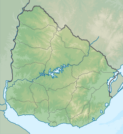
The Asencio Formation is a geological formation in the Paraná Basin of southwestern Uruguay whose strata date back to the Late Cretaceous (Campanian-Maastrichtian). Dinosaur remains are among the fossils that have been recovered from the formation.[1]
Vertebrate paleofauna
Fossil eggs
See also
- List of dinosaur-bearing rock formations
- List of fossiliferous stratigraphic units in Uruguay
- Adamantina Formation
- Allen Formation
- Marília Formation
References
- ^ Weishampel et al., 2004, pp. 600-604
- ^ a b c Drable-Palmitas at Fossilworks.org
- ^ a b Mones, A. (1980) "Nuevos elementos de la paleoherpetofauna del Uruguay (Crocodilia y Dinosauria)." Actas II Congreso Argentino de Paleontologia y Bioestratigrafia y I Congreso Latinoamericano, Buenos Aires 1:265-277 (in Spanish)
Bibliography
Further reading
- F. v. Huene. 1929. Terrestrische Oberkreide in Uruguay [The terrestrial Upper Cretaceous in Uruguay]. Centralblatt für Mineralogie, Geologie und Paläontologie Abteilung B 1929:107-112
Categories:
- Geologic formations of Uruguay
- Upper Cretaceous Series of South America
- Cretaceous Uruguay
- Campanian Stage
- Maastrichtian Stage of South America
- Sandstone formations
- Ooliferous formations
- Paleontology in Uruguay
- Paraná Basin
- Geography of Colonia Department
- Geography of Río Negro Department
- Geography of Soriano Department
- Geography of Tacuarembó Department

