M'Bour
M'Bour | |
|---|---|
Town | |
 | |
| Coordinates: 14°25′N 16°58′W / 14.417°N 16.967°W | |
| Country | Senegal |
| Region | Thiès Region |
| Department | M'Bour |
| Time zone | UTC+0 (GMT) |

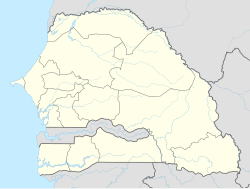
M'Bour or Mbour (Wolof: Mbuur), is a city in the Thiès Region of Senegal. It lies on the Petite Côte, approximately eighty kilometers south of Dakar. It is home to a population of nearly 233,000 (2013 census).
The city's major industries are tourism, fishing and peanut processing[citation needed]. M'Bour is a tourist destination. It is situated on the "Little Coast" and connected to Dakar via the N1 road.
It is noteworthy for the orphanage and nursery for children run by the international NGO Vivre Ensemble, and for the African Institute for Mathematical Sciences, Senegal.
140 migrants drowned on October 29, 2020 when a boat from M'Bour that was bound for the Canary Islands capsized near Saint-Louis, Senegal.[1]
Notable residents or natives
- Viviane N'Dour, Singer
- Youssou Diagne, Politician
- Ibrahima Niane, Footballer
See also
Gallery
-
Port of M'Bour in Senegal
-
Port of M'Bour, Senegal
-
Streets near the port of M'Bour, Senegal
14°25′N 16°58′W / 14.417°N 16.967°W
- ^ Braithwaite, Sharon; McSweeney, Eoin (October 29, 2020). "At least 140 people drown in the deadliest shipwreck of 2020". CNN. Retrieved November 17, 2020.


