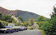
Aberllefenni railway station
Aberllefenni | |
|---|---|
 A train at Aberllefenni in c. 1897 showing the loop south of the platform | |
| General information | |
| Location | Wales |
| Other information | |
| Status | Closed |
| History | |
| Pre-grouping | Corris Railway |
| Post-grouping | Great Western Railway (after 1930) |
| Key dates | |
| 1887 | Opened to passengers |
| 1931 | Closed to passengers |
| 1948 | Closed to freight |
Aberllefenni was a station on the Corris Railway in Merioneth (now Gwynedd), Wales. It was opened in 1887 as the northern passenger terminus of the railway. It closed to passengers in 1931, and to all traffic in 1948.
History
The Corris Railway (originally called the Corris Machynlleth and River Dovey Tramroad) opened in 1858, connecting the slate quarries around Corris and Aberllefenni with river wharves at Derwenlas and Morben. The tramroad started at the "engine house" (ie slate mill) at Aberllfenni quarry, to the north of the eventual station site.[1]
Passengers were carried on the Corris from around 1860, and a timetabled service was introduced in October 1874. The early services appear to have run between Machynlleth Town and Corris[2] though the quarry trains on to Aberllefenni and Ratgoed may well have carried workers on an informal basis.[3]
The railway was upgraded for steam locomotives in 1878, though steam-hauled passenger services didn;t start until 1883. Initially these ran from Machynlleth to Corris. In 1887, a new station was opened at Aberllefenni, and passenger trains terminated there until the end of passenger trains on the line in 1931.[1]
Location
The station was sited on a thin sliver of land next to the road into the village. The station building was unusually narrow to fit in the available land, and there wasn't enough room to put a passing loop next to the low slate platform. Instead, a loop was built immediately south of the platform, which required locomotives to make extra shunting operations to run round their trains. The passing loop had an inspection pit.[4]
The line north of the station was gated - this marked the boundary between the locomotive-operated railway and the Ratgoed Tramway and quarry branches beyond. The track split at a single-bladed point just beyond, with the left branch passing behind Pensarn - the main set of cottages in the village - and on to Ratgoed quarry. The right branch crossed the road and ran down to the village mill and beyond to the Aberllefenni quarries.[5]
After closure

The Ratgoed tramway continued in use until 1952,[6] and parts of the Aberllefenni quarry tramway were used until the Foel Grochan mine closed in 2003.[7]
The station building gradually deteriorated after the closure of the Corris Railway, though it survived until at least 1962.[1] In 1964 the station site was purchased by the Forestry Commission and the remains of the building was offered to the nascent railway society on the condition that they removed it, but this offer was not taken up.[8]
Roadworks have removed some of the station site, and the only remaining structures are the retaining wall of the station foundations and the slate stairs that used to lead into the station building.[1]
References
- ^ a b c d Johnson, Peter (2011). An Illustrated History of the Great Western Narrow Gauge. Oxford Publishing Co.
- ^ MRFS; Quine, Dan (July 2024). "Corris Railway Stations at Machynlleth Before Steam". Narrow Gauge and Industrial Railway Modelling Review (139). RCL Publications.
- ^ Quine, Dan (April 2020). "Early Corris Railway passenger trains". Narrow Gauge and Industrial Railway Modelling Review (122).
- ^ Briwnant Jones, Gwyn (1994). Great Western Corris. Gomer Press.
- ^ The Corris Railway Society (1988). A Return to Corris. Avon-Anglia Publications & Services. ISBN 978-0905466897.
- ^ Philip John Greer Ransom (1981). The archaeology of railways. World's Work. ISBN 978-0-437-14401-0.
- ^ Knowles, Jon (2023). Aberllefenni Slate Quarry. ISBN 9781399951678.
- ^ Bourne, Mark (21 February 1964). "Miles of new roads - but not for motorists". Liverpool Daily Post (Welsh Edition). p. 6.
| Preceding station | Disused railways | Following station | ||
|---|---|---|---|---|
| Garneddwen | Corris Railway | Cymerau quarry |
