Anaco
Appearance
You can help expand this article with text translated from the corresponding article in Spanish. Click [show] for important translation instructions.
|
Anaco | |
|---|---|
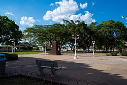
 Bolivar Square in Anaco. | |
| Coordinates: 9°28′55″N 64°29′30″W / 9.48194°N 64.49167°W | |
| Country | |
| State | Anzoátegui |
| Municipality | Anaco Municipality |
| Founded | 1944 |
| Elevation | 215 m (705 ft) |
| Population (2005) | |
• Total | 106,000 |
| • Demonym | Anaquense |
| Time zone | UTC−4 (VET) |
| Postal code | 6003 |
| Area code | 0282 |
| Climate | Aw |
Anaco is a city in Anzoátegui State, Venezuela, the shire town of Anaco Municipality. It is an industrial town, connected to the natural gas and petroleum industries. Estimated population (as of 2005): 106,275 inhabitants.[1]
Transport
The city is served by Anaco Airport. No longer in service for commercial flights. Anaco is on the San Tomé-Puerto la Cruz highway that connects the town with San Tomé and El Tigre to the south and Puerto la Cruz on the coast.[citation needed]
Notable people

- Omar Rudberg, singer and actor.
- Nathalie Rayes, activist and sociologist.
- Orlando Arcia, Atlanta Braves shortstop, younger brother of Oswaldo Arcia
- Oswaldo Arcia, Minnesota Twins outfielder, older brother of Orlando Arcia
- Ruddy Rodríguez – former Miss Venezuela
- Miguel Cairo – Professional baseball player
References
External links
Wikivoyage has a travel guide for Anaco.
Wikimedia Commons has media related to Anaco.
- http://www.anacoweb.net Website


