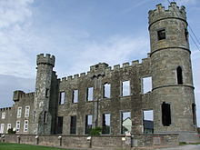
Ballyheigue Castle

Ballyheigue Castle, in Ballyheigue, County Kerry, is a ruined Tudor-gothic-revival-style mansion. It was used as a residence of the Crosbie family (including the Bishop of Ardfert and Aghadoe, High Sheriffs of Kerry and members of the UK Parliament) and later as a gaol. It has been burned twice. It is currently part of a golf course.
History
It was enlarged in 1809 to a design by Richard Morrison on the site of an earlier house built in 1758 and incorporated part of the fabric of the original building. The 'castle' aspect of the name relates to the crenellations of the parapet. The large two-storey south-facing elevation with the entrance consisted of six bays flanked by three-storey, single-bay circular corner turrets. It was originally thatched and faced an enclosed courtyard. The site was the property of the Crosbie family, historically associated with the bishopric of Ardfert from the time of the Right Reverend John Crosbie (formerly Sean Mac an Chrosáin); before then the Mac an Chrosáin family were a bardic family of Leinster. From 1709, the property was the possession of Thomas Crosbie, member of parliament (MP) for Kerry (1709–10) and Dingle (1713-1731), High Sheriff of Kerry in 1712 and 1714. The line of succession followed: James Crosbie (1731, High Sheriff in 1751); Pierce Crosby (1761, High Sheriff in 1779, 1797); James Crosbie (1797, High Sheriff 1792, MP for Kerry (1797-1800); Pierce Crosbie (1836, High Sheriff 1815); James Crosbie (High Sheriff 1862, colonel Kerry Militia); James Dayrolles Crosbie (1865-1947) (High Sheriff 1894, Deputy Lieutenant Co. Kerry 1900, chairman of Tralee & Fenit Railway Co., Brigadier-General 1916–17, JP).[1][2][3][4][5]

War of Independence
From 1890, parts of the site were used a Royal Irish Constabulary (RIC) station. On the 1 December 1912, a hay shed at the Castle was set on fire; the following day, two further hay sheds were similarly destroyed, burning 200 tons of hay. James Crosbie made a claim for £1000 damages. From 1916 through to 1920, Crosbie auctioned the demesne lands of the estate to local people and also sold the Castle to Jeremiah Leen, ending the Crosbie connexion with Ballyheigue. In early 1921, the building was vacant. Later, a Mr. R. Palmer and Mrs. Erskine were resident in the castle for a few weeks. Erskine was involved in some Castle-related transaction with Palmer, a proprietor of local creameries. He planned to live in England and informed Michael Pierce, captain of the Ballyheigue Company of the Irish Volunteers, that the building was to be occupied by the British military. Pierce informed his battalion OC. In March 1921, the building was occupied by elements of the Royal Irish Constabulary. Following a sweep across north Kerry from the coast as far as Kilflynn to find IRA members, hundreds of men were detained in outbuildings on the site. On 25 May 1921, an auction of the buildings' contents was held at the castle. On 27 May, it was attacked and burned by local Irish Volunteers. In October the same year, Palmer was awarded £127 compensation by a Tralee court for furniture lost in the blaze. On 14 June 1923, Leen won a case in the King's Bench Division against Lloyd's of London underwriters who argued that he'd neglected to inform them that Crown forces had occupied the site and Sinn Fein members were interned there; he was awarded £9,500 and costs. During the proceedings, Thomas Clifford, a draper's assistant and IRA officer, admitted starting the blaze with petrol on floorboards after being ordered to destroy the castle.[6][7][8][9][10][11][12][13][14][15][16]
Apartments
A low part of the building to the left of the front elevation was reconstructed and remodelled as apartments in 1975.[17]
Golf course
In 1998, Ballyheigue Castle Golf Course was officially opened by the Minister for Foreign Affairs, Dick Spring T.D.[18]
References
- ^ "Ballyheige Castle". www.buildingsofireland.ie. Retrieved 14 January 2023.
- ^ "Dublin". Saunders's Newsletter. Dublin. 8 February 1779.
- ^ "Crosbie, Brig.-Gen. James Dayrolles". en.wikisource.org. Retrieved 14 January 2023.
- ^ "Tralee and Fenit Railway Co". Dublin Daily Express. Dublin. 25 August 1906. p. 3.
- ^ "New Deputy Lieutenant For County Kerry". Weekly Irish Times. Dublin. 8 December 1900. p. 1.
- ^ "The Fires at Ballyheigue Castle". Kerry People. Kerry. 21 December 1912. p. 3.
- ^ "Meadowing at Ballyheigue Castle". Kerry Evening Post. Kerry. 8 July 1916. p. 2.
- ^ "Ballyheigue Castle". Kerry People. Kerry. 12 October 1918. p. 2.
- ^ "Ballyheigue Castle". www.mysteriousbritain.co.uk. Retrieved 22 January 2023.
- ^ https://www.militaryarchives.ie/collections/online-collections/bureau-of-military-history-1913-1921/reels/bmh/BMH.WS1190.pdf
- ^ "'One Irregular was killed': The death of John Lawlor of Ballyheigue, Co. Kerry, 31 October 1922". www.theirishstory.com. Retrieved 5 January 2023.
- ^ "Castle On Fire In Kerry". Evening Herald Dublin. Dublin. 28 May 1921.
- ^ "Ballyheigue Castle, Ballyheigue: Important Sale by Public Auction of Very High-Class Furniture". Kerry People. Kerry. 21 May 1921.
- ^ "Kerry Claims". Evening Herald Dublin. Dublin. 13 October 1921.
- ^ ""Days of Barbarism"". Northern Whig. Belfast. 15 June 1923.
- ^ "The Man Who Burned The Castle". Londonderry Sentinel. Derry. 16 June 1923. p. 7.
- ^ "Ballyheigue Castle". www.geograph.ie. Retrieved 22 January 2023.
- ^ "Course History". www.ballyheiguegolfclub.com. Retrieved 14 January 2023.
