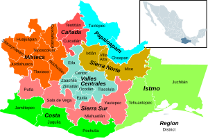
Choapam District
Appearance
Choapam District | |
|---|---|
District | |
 Oaxaca regions and districts: Papaloapan to Northeast | |
| Coordinates: 17°20′N 95°57′W / 17.333°N 95.950°W | |
| Country | |
| State | Oaxaca |
Choapam District is located in the south of the Papaloapan Region of the State of Oaxaca, Mexico. It covers 3,166 km2, and as of 2005 had a population of 37,809. Its southwestern portion is mountainous, while the northeast is in the coastal plain of the gulf of Mexico. [1]
Municipalities

The district includes the following municipalities:[1]
| Municipality | Area km2 | 2005 Population |
|---|---|---|
| San Juan Comaltepec | 163 | 2,389 |
| San Juan Lalana | 454 | 11,385 |
| San Juan Petlapa | 254 | 2,717 |
| Santiago Choapam | 248 | 3,392 |
| Santiago Jocotepec | 732 | 12,423 |
| Santiago Yaveo | 1,315 | 5,503 |
References
- ^ a b "Enciclopedia de los Municipios de México: Estado de Oaxaca". Archived from the original on 2010-07-10. Retrieved 2010-07-08.
