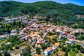
Doukades
Doukades
Δουκάδες | |
|---|---|
 | |
| Coordinates: 39°41′N 19°44′E / 39.683°N 19.733°E | |
| Country | Greece |
| Administrative region | Ionian Islands |
| Regional unit | Corfu |
| Municipality | Central Corfu and Diapontia Islands |
| Municipal unit | Palaiokastritsa |
| Population (2021)[1] | |
• Community | 487 |
| Time zone | UTC+2 (EET) |
| • Summer (DST) | UTC+3 (EEST) |
| Vehicle registration | ΚΥ |

Doukades (Greek: Δουκάδες) is a village and a community in the northwestern part of the island of Corfu. It is located in the municipal unit of Palaiokastritsa. The community includes the village Papathanatika. Hills dominate the area.
Population
| Year | Settlement population | Community population |
|---|---|---|
| 1981 | 491 | - |
| 1991 | 492 | - |
| 2001 | 678 | 689 |
| 2011 | 630 | 724 |
| 2021 | 407 | 487 |
History
According to I. Bounia, the name of the settlement came from its first inhabitants who bore the name Doukas (Δούκας, meaning duke). The earliest written reference to Doukades is a notary writing from 1616. Of interest are the restored stone mansion of the family Theotokis, the Venetian type "Sagrado" of Kouartano, and the building of the elementary school at the entrance of the village.
Doukades was characterized as a traditional settlement with the law of October 19, 1978 No. 594 IV / November 13, 1998 (Codical statistics, number 22.1.137.01).
See also
References
- ^ "Αποτελέσματα Απογραφής Πληθυσμού - Κατοικιών 2021, Μόνιμος Πληθυσμός κατά οικισμό" [Results of the 2021 Population - Housing Census, Permanent population by settlement] (in Greek). Hellenic Statistical Authority. 29 March 2024.

