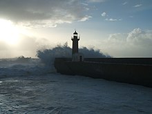
Foz do Douro
Foz do Douro | |
|---|---|
 | |
| Coordinates: 41°09′00″N 8°40′01″W / 41.150°N 8.667°W | |
| Country | |
| Region | Norte |
| Metropolitan area | Porto |
| District | Porto |
| Municipality | Porto |
| Disbanded | 2013 |
| Area | |
• Total | 1.88 km2 (0.73 sq mi) |
| Population (2011) | |
• Total | 10,997 |
| • Density | 5,800/km2 (15,000/sq mi) |
| Time zone | UTC+00:00 (WET) |
| • Summer (DST) | UTC+01:00 (WEST) |

Foz do Douro (Portuguese pronunciation: [ˈfɔʒ ðu ˈðoɾu]; meaning "Mouth of the Douro") is a former civil parish in the municipality of Porto, Portugal. In 2013, the parish merged into the new parish Aldoar, Foz do Douro e Nevogilde.[1] The population in 2011 was 10,997,[2] in an area of 1.88 km2.[3] It became a parish in 1836. It is located in the western part of Porto, next to the mouth of the Douro river and the Atlantic Ocean.
History
The first king of Portugal, Afonso Henriques, donated a chapel in São João da Foz in 1145. In the 13th century the chapel became part of the Benedictine monastery of Santo Tirso. The borders of the parish, called Couto da Foz, were limited by the city of Bouças (Matosinhos) in the north and Porto, to the east.[4]
References
- ^ Diário da República. "Law nr. 11-A/2013, pages 552 99-100" (pdf) (in Portuguese). Retrieved 29 July 2014.
- ^ Instituto Nacional de Estatística
- ^ Eurostat Archived September 6, 2014, at the Wayback Machine
- ^ "Going to the seaside at Foz - The summer time and the appeal of the beach - Porto by Livraria Lello". Porto by Livraria Lello. 2017-07-03. Retrieved 2017-09-13.

