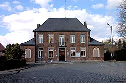
Frasnes-lez-Gosselies
Appearance
Les Bons Villers | |
|---|---|
 Les Bon Villiers Community House | |
| Coordinates: 50°31′53″N 4°26′46″E / 50.53147°N 4.44616°E | |
| Country | |
| Community | French Community |
| Region | Wallonia |
| Province | Hainaut |
| Arrondissement | Charleroi |
| Government | |
| • Mayor | Emmanuel Wart (MR-IC) |
| • Governing party/ies | MR-IC, PS |
| Area | |
• Total | 42.97 km2 (16.59 sq mi) |
| Postal codes | 6210 |
| NIS code | 52075 |
| Area codes | 071 |
| Website | www.les-bons-villers.be |
Frasnes-lez-Gosselies (Walloon: Fråne-dilé-Gochliye) is a village of Wallonia and a district of the municipality of Les Bons Villers, located in the province of Hainaut, Belgium.
Former names
Fraxina (1146 ; 1147 ; 1148), Frasna (1148), Fraine (1205 ; ±1210), Fraxinensis (1205), Fraina (1222).[1]
Notable natives of Frasnes-lez-Gosselies
- Adolphe Biarent (1871–1916), composer
- Paul Vanderborght (1899–1971), poet
- Jean Duvieusart (1900–1977), Former Prime Minister
References
- ^ Gysseling, Maurits (1960). "Toponymisch woordenboek van België, Nederland, Luxemburg, Noord-Frankrijk en West-Duitsland (vóór 1226)". Tongres, Belgisch Interuniversitair Centrum voor Neerlandistiek. p. 375.


