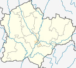
Gučkampis
Appearance
Gučkampis | |
|---|---|
Village | |
 | |
| Coordinates: 55°09′50″N 23°36′50″E / 55.16389°N 23.61389°E | |
| Country | |
| County | |
| Municipality | Kėdainiai district municipality |
| Eldership | Pernarava Eldership |
| Population (2011) | |
• Total | 24 |
| Time zone | UTC+2 (EET) |
| • Summer (DST) | UTC+3 (EEST) |
Gučkampis (formerly Russian: Гучкомпе, Polish: Guczkompie)[1] is a village in Kėdainiai district municipality, in Kaunas County, in central Lithuania. According to the 2011 census, the village had a population of 24 people.[2] It is located 1 kilometre (0.62 mi) from Liučiūnai, on a high hill. There is an old cemetery.
History
An ancient stone axe have been found in Gučkampis. The village have been known since 1609.[3] It was a royal village in the 18th century. At that time it belonged to the marshall of Raseiniai Jurgis Liaudanskas.
In 1950–1954 and 1963–1968 Gučkampis was a selsovet center.
Demography
|
| ||||||||||||||||||||||||||||||||||||
| Source: 1902, 1923, 1959 & 1970, 1979, 1989, 2001, 2011 | |||||||||||||||||||||||||||||||||||||
References
- ^ "Guczkompie". Geographical Dictionary of the Kingdom of Poland (in Polish). 15 pt. 1. Warszawa: Kasa im. Józefa Mianowskiego. 1900. p. 544.
- ^ "2011 census". Statistikos Departamentas (Lithuania). Retrieved August 21, 2017.
- ^ "Gučkampis". Tarybų Lietuvos enciklopedija (in Lithuanian). Vol. 2. Vilnius: Vyriausioji enciklopedijų redakcija. 1986. p. 11.


