Hantai District
Appearance
You can help expand this article with text translated from the corresponding article in Chinese. (December 2008) Click [show] for important translation instructions.
|
Hantai
汉台区 | |
|---|---|
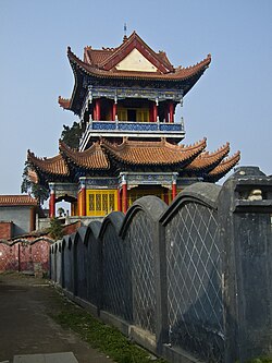
 Wengong Daoist Temple (文公祠道观) | |
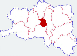
 Location in Hanzhong | |
 Hanzhong in Shaanxi | |
| Coordinates: 33°04′04″N 107°01′55″E / 33.0678°N 107.0319°E | |
| Country | People's Republic of China |
| Province | Shaanxi |
| Prefecture-level city | Hanzhong |
| Established | February 21, 1996 |
| Area | |
• Total | 556 km2 (215 sq mi) |
| Population (2019) | |
• Total | 570,900 |
| • Density | 1,000/km2 (2,700/sq mi) |
| Time zone | UTC+8 (China standard time) |
| Postal code | 723000 |
| Area code | (0)916 |
| Licence plates | 陕F |
| Website | www |
Hantai District (simplified Chinese: 汉台区; traditional Chinese: 漢台區 / 漢臺區; pinyin: Hàntái Qū), is a district and the seat of the city of Hanzhong, Shaanxi province, China.
Administrative divisions
As 2019, Hantai District is divided to 8 subdistricts and 7 towns.[1]
- Subdistricts
|
|
- Towns
|
|
References
- ^ "统计用区划代码 www.stats.gov.cn" (in Chinese). XZQH. Retrieved 2021-01-02.
