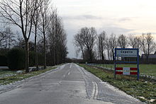
Kapelle, Schouwen-Duiveland

Capelle | |
|---|---|
 | |
| Coordinates: 51°38′43″N 3°58′3″E / 51.64528°N 3.96750°E | |
| Country | Netherlands |
| Province | Zeeland |
| Municipality | Schouwen-Duiveland |
Kapelle (formerly Capelle) is a hamlet in the Dutch province of Zeeland. It is located on the island of Schouwen-Duiveland, about 2 km west of Nieuwerkerk.
Until 1813, the hamlet was part of the separate municipality of Capelle en Botland.[1] In 1953, Capelle had grown into a small village, with about 20 houses and a population of around 100, when it was almost completely destroyed in the North Sea flood of 1953.[2] All houses except two were swept away, and 42 inhabitants died.
The village was not rebuilt; nowadays only a small hamlet remains, consisting of a number of farms.
Kapelle should not be confused with some other locations in Zeeland: the hamlet of Looperskapelle on Schouwen-Duiveland, about 12 km to the northwest, which was formerly also known as "Kapelle", and the much larger town of Kapelle on Zuid-Beveland.
References
- ^ "Gemeentegeschiedenis". www.gemeentegeschiedenis.nl. Retrieved 2022-06-08.
- ^ "Meekrap- en cichoreifabriek in Capelle". Zeeuwse Ankers (in Dutch). Retrieved 2022-06-08.
51°39′N 3°58′E / 51.650°N 3.967°E
