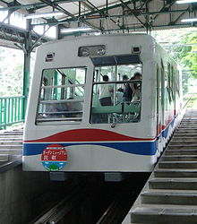
Keifuku Cable Line
Appearance

Keifuku Electric Railroad | ||||||||||||||||||||||||||||||||||||||||||||||||||||||||||||||||||||||
|---|---|---|---|---|---|---|---|---|---|---|---|---|---|---|---|---|---|---|---|---|---|---|---|---|---|---|---|---|---|---|---|---|---|---|---|---|---|---|---|---|---|---|---|---|---|---|---|---|---|---|---|---|---|---|---|---|---|---|---|---|---|---|---|---|---|---|---|---|---|---|
| ||||||||||||||||||||||||||||||||||||||||||||||||||||||||||||||||||||||
| ||||||||||||||||||||||||||||||||||||||||||||||||||||||||||||||||||||||
The Eizan Cable (叡山ケーブル, Eizan Kēburu), officially the Cable Line (鋼索線, Kōsaku-sen), is Japanese funicular line in Sakyō, Kyōto, Kyōto, operated by Keifuku Electric Railroad. The line opened in 1925, as a western route to Enryaku-ji, a famous temple on Mount Hiei. The line has 561 m (1,841 ft) vertical interval, the largest in the country.[1]
Basic data
- Distance: 1.3 km (0.81 mi)
- Gauge: 1,067 mm (3 ft 6 in)
- Stations: 2
- Vertical interval: 561 m (1,841 ft)
See also
- List of funicular railways
- List of railway lines in Japan
- Sakamoto Cable – on the other side of the mountain
References
- ^ "叡山ケーブル・ロープウェイを楽しもう! | 比叡山の観光に、京都、出町柳から比叡山山頂、京都八瀬をつなぐ叡山ケーブル・ロープウェイ". 2017-03-14. Archived from the original on 2017-03-14. Retrieved 2024-11-03.
External links
- Keifuku official website (in Japanese)
35°3′54.4″N 135°48′56.2″E / 35.065111°N 135.815611°E
