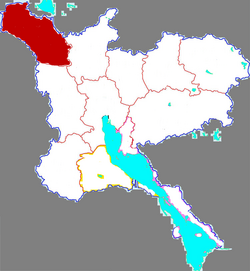
Liangshan County
This article needs additional citations for verification. (January 2021) |
Liangshan County
梁山县 | |
|---|---|
 Location in Jining | |
| Coordinates: 35°48′45″N 116°06′10″E / 35.81250°N 116.10278°E | |
| Country | People's Republic of China |
| Province | Shandong |
| Prefecture-level city | Jining |
| Area | |
• Total | 961 km2 (371 sq mi) |
| Population (2019)[1] | |
• Total | 847,894 |
| • Density | 880/km2 (2,300/sq mi) |
| Time zone | UTC+8 (China Standard) |
| Postal code | 272600 |
| Website | www |
Liangshan County (Chinese: 梁山县; pinyin: Liángshān Xiàn) is a county situated in the southwest of Shandong province, China. It is administered by the prefecture-level city of Jining.
Geography
Liangshan County is situated north west of Jining in the south west of Shandong province. To the east it borders the prefecture-level cities of Tai'an, Heze to the west. To the north, the Yellow River separates Liangshan from Puyang, in Henan province.
Climate
| Climate data for Liangshan (1991–2020 normals, extremes 1981–2010) | |||||||||||||
|---|---|---|---|---|---|---|---|---|---|---|---|---|---|
| Month | Jan | Feb | Mar | Apr | May | Jun | Jul | Aug | Sep | Oct | Nov | Dec | Year |
| Record high °C (°F) | 16.5 (61.7) |
23.9 (75.0) |
28.3 (82.9) |
33.5 (92.3) |
37.0 (98.6) |
41.7 (107.1) |
40.7 (105.3) |
36.1 (97.0) |
35.4 (95.7) |
35.1 (95.2) |
26.5 (79.7) |
20.5 (68.9) |
41.7 (107.1) |
| Mean daily maximum °C (°F) | 4.4 (39.9) |
8.5 (47.3) |
14.6 (58.3) |
20.9 (69.6) |
26.4 (79.5) |
31.6 (88.9) |
31.9 (89.4) |
30.4 (86.7) |
27.0 (80.6) |
21.4 (70.5) |
13.0 (55.4) |
6.1 (43.0) |
19.7 (67.4) |
| Daily mean °C (°F) | −1.0 (30.2) |
2.6 (36.7) |
8.4 (47.1) |
14.7 (58.5) |
20.4 (68.7) |
25.6 (78.1) |
27.2 (81.0) |
25.7 (78.3) |
21.1 (70.0) |
15.1 (59.2) |
7.3 (45.1) |
0.9 (33.6) |
14.0 (57.2) |
| Mean daily minimum °C (°F) | −5.2 (22.6) |
−2.0 (28.4) |
3.1 (37.6) |
9.2 (48.6) |
14.8 (58.6) |
20.2 (68.4) |
23.3 (73.9) |
22.0 (71.6) |
16.5 (61.7) |
10.0 (50.0) |
2.8 (37.0) |
−3.2 (26.2) |
9.3 (48.7) |
| Record low °C (°F) | −20.5 (−4.9) |
−16.6 (2.1) |
−11.1 (12.0) |
−4.4 (24.1) |
3.0 (37.4) |
9.9 (49.8) |
16.3 (61.3) |
11.4 (52.5) |
4.3 (39.7) |
−3.2 (26.2) |
−13.3 (8.1) |
−16.5 (2.3) |
−20.5 (−4.9) |
| Average precipitation mm (inches) | 5.6 (0.22) |
10.5 (0.41) |
13.7 (0.54) |
31.7 (1.25) |
49.5 (1.95) |
66.9 (2.63) |
152.3 (6.00) |
133.3 (5.25) |
56.1 (2.21) |
30.0 (1.18) |
26.3 (1.04) |
7.8 (0.31) |
583.7 (22.99) |
| Average precipitation days (≥ 0.1 mm) | 2.8 | 3.7 | 3.7 | 5.2 | 6.4 | 7.4 | 10.6 | 10.1 | 7.1 | 5.4 | 4.7 | 2.9 | 70 |
| Average snowy days | 2.8 | 2.5 | 0.6 | 0.2 | 0 | 0 | 0 | 0 | 0 | 0 | 0.8 | 1.9 | 8.8 |
| Average relative humidity (%) | 64 | 61 | 58 | 65 | 68 | 64 | 79 | 84 | 78 | 71 | 70 | 68 | 69 |
| Mean monthly sunshine hours | 140.9 | 147.5 | 198.0 | 224.2 | 246.3 | 219.9 | 196.2 | 190.0 | 185.0 | 185.0 | 152.8 | 141.6 | 2,227.4 |
| Percent possible sunshine | 45 | 48 | 53 | 57 | 57 | 51 | 45 | 46 | 50 | 54 | 50 | 47 | 50 |
| Source: China Meteorological Administration[2][3] | |||||||||||||
History
The area was from prehistoric times surrounded by the largest marshland in north China, called the Daye Marsh and later the Liangshan Marsh. Because the area was largely a wasteland on the frontiers of several administrative units, government control was minimal, and bandit chiefs were active in the area. During the Song dynasty Liang Shan (Mount Liang) became known as the "eight hundred li moorage of Mount Liang" and located at the extreme north of the Yellow River which passed through the area. When the Yellow River shifted course in 1289, the marshes of Liangshan shrunk considerably. During the Ming dynasty it had been reduced to five smaller marshlands. Banditry continued on Mount Liang until the mid-seventeenth century, when the Qing dynasty government established a military garrison. The city of Liangshan evolved from the garrison. After the Yellow River shifted back to its northern course in 1853, the marshes were gradually filled in by sediments carried downstream by the river and human land reclamation. Today the relatively small Dongping Lake(Chinese: 东平湖; pinyin: Dōngpíng Hú) is what remains of the great marshes.
Administrative divisions
As 2012, this county is divided to 9 towns and 4 townships.[4]
- Towns
|
|
- Townships
|
|
Tourism
The famous mountain Mount Liang (Liáng Shān) rises to 197.9 m above sea level is located within Liangshan County administrative territory. It is well known as the stronghold of the 108 legendary Song dynasty heroes of the classic Chinese novel the Water Margin.
Transportation
References
- ^ "China : Population - ceicdata.com". ceicdata. Retrieved 2021-01-05.
- ^ 中国气象数据网 – WeatherBk Data (in Simplified Chinese). China Meteorological Administration. Retrieved 12 August 2023.
- ^ 中国气象数据网 (in Simplified Chinese). China Meteorological Administration. Retrieved 12 August 2023.
- ^ 济宁市-行政区划网 www.xzqh.org (in Chinese). XZQH. Retrieved 2012-05-24.
- http://www.cfguide.com/county/Liangshan.htm
- https://web.archive.org/web/20170819191901/http://www.liangshan.gov.cn/index.aspx?lanmuid=40&sublanmuid=438

