Sant Pere, Barcelona
Appearance
Sant Pere | |
|---|---|
 Plaça de Sant Pere, with Sant Pere de les Puelles in the background | |
 Map of Sant Pere, Santa Caterina i la Ribera within Barcelona | |
| Country | |
| Autonomous Community | |
| Province | |
| Comarca | Barcelonès |
| Municipality | |
| District | Ciutat Vella |
| Neighborhood | Sant Pere, Santa Caterina i la Ribera |
| Postal code | 08003 |
Sant Pere (Catalan pronunciation: [ˈsam ˈpeɾə], Barri de Sant Pere in Catalan) is a traditional neighborhood of the old city of Barcelona, Spain. It is named after the monastery Sant Pere de les Puelles. Nowadays, it is a part of the Sant Pere, Santa Caterina i la Ribera neighborhood.
Points of interest
- The neighborhood received its name from the 10th century monastery of Sant Pere de les Puelles, (Saint Peter of the Innocents),[1] at Lluís El Piadós 1. The monastery is named after girls that disfigured themselves to avoid rape and murder.[2]
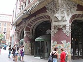
- The Palau de la Música Catalana (Palace of Catalan Music) concert hall designed by Lluís Domènech i Montaner is located at Carrer Sant Francesc de Paula 2.[3]
Gallery
References
Wikimedia Commons has media related to Sant Pere, Santa Caterina i la Ribera.
- ^ "Barri de Sant Pere - Information". Homeandabroad.com. Archived from the original on 2008-12-05. Retrieved 2008-11-06.
- ^ "Terra": Review of Sant Pere de les Puells
- ^ "Time Out Online" Archived 2008-07-26 at the Wayback Machine


